
Are you interested in any aspect
of marine life? Do you want to learn or understand more about
the underwater world? Do you want to campaign against the pollution
of our oceans and the destruction of reefs and seagrass beds?
If so, our Society (MLSSA) caters for people just like you.
Our motto is "--- understanding,
enjoying and caring for our oceans ---". These few words
summarise our members' motives. Members seek to understand our
ocean, derive enjoyment from observations of marine life and are
committed to its protection.
When you become a Society member
you will enjoy contact with others with similar interests. Our
members include divers, marine aquarists and naturalists. Our
aim is to promote a better understanding of our marine environment.
Our activities include:-
-Studying our local marine environment
-Education
-Scuba diving
-Underwater photography
-Marine aquaria
Established in 1976, MLSSA holds
monthly meetings and field trips. We produce various informative
and educational publications including a monthly Newsletter and
an annual Journal. Our library is a source of helpful information
for marine enthusiasts.
Through our affiliation with other
organisations (i.e. Conservation Council of S.A. and the Scuba
Divers Federation of S.A.) we are kept up to date with relevant
issues of interest. MLSSA also has close ties with appropriate
Government organisations, e.g. various museums, universities and
libraries.
If you wish to join our Society
you will note that we have subscription levels for students, individuals,
families and organisations. Concessional rates may be available,
on application to the Treasurer, by eligible persons. We invite
you to download the membership form in this Webpage and send it
with your payment to MLSSA at the following address:-
MLSSA Inc.
120 Wakefield Street,
ADELAIDE
South Australia 5000
This is the MLSSA Journal, an
official publication of the Marine Life Society of South Australia
Inc.
Our Society is active in trying
to protect our marine environment and this Journal mainly contains
articles about marine life.
Copyright
- The MLSSA Journal is a publication of the Marine Life Society
of South Australia Inc. and is copyright 1998. The contents may
not be reproduced without prior permission of the Society or the
Copyright holder.
Disclaimer
- The opinions expressed by authors of material published in this
Journal are not necessarily those of the Society.
Contributions should be mailed
to MLSSA, at 120 Wakefield Street, Adelaide S.A. 5000 or
sent by e-mail to- mlssa@cobweb.com.au
Although every care will be taken
with contributions, no responsibility will be assumed for any
loss or damage thereto.
The act of submitting a manuscript
shall constitute a warranty by the contributor that the material
is original, and is in no way an infringement upon the rights
of others.
It shall also be an affirmation
of the fact that the material is submitted for publication subject
to any revision that is deemed necessary by the Editor to meet
the requirements of publication.
Everyone is welcome to attend
our General Meetings which are usually held on the third Wednesday
of every month (except December) at the Conservation Centre, 120
Wakefield Street, Adelaide, beginning at 8pm.
Welcome to the 1998 MLSSA Journal.
We hope you not only enjoy this edition but can also find something
new in the articles that are published.
Over the last few years the MLSSA Journal has been steadily developing. This has been partly due to the larger number of quality articles contributed by different people and also by our desire for a larger, and more colourful Journal.
We have published several articles by professional people in the Marine Sciences field and also contributions from MLSSA Members. These have been interspersed with articles from a new generation who are still at school. They show some immaturity of style and thought coupled with a delightful tendency to oversimplify solutions to complex issues. However, their ideas may lead people to see these problems in a new light.
We thank all the people who have contributed their work and their time to this Journal. they gave so willingly.
Our Journals are also contributing
to the interest being generated by our Webpage. This is shown
by the number of hits being registered on our 1997 Journal. It
has also resulted in several E-mails either asking for more information
on some of the articles, or by people wanting to link to our Journal
page.
1) School of Applied Science, Griffith University, Gold Coast, Qld, 9726
Summary
Saltmarshes are an important ecological
habitat covering large tracts of the upper intertidal zone of
estuaries in all parts of Australia. Fish associated with Australian
saltmarshes have previously been sampled from within creeks or
semi-permanent pools on the marsh, but this is the first record
of fish use of marsh flats inundated on high tides but emergent
on low tides. Buoyant pop nets (9 m², 1 mm mesh)
were used to collect fish from 2 areas of the marsh flat on Torrens
Island in the Barker Inlet - Port River estuary, South Australia.
Fyke nets of the same mesh size were used to collect fish from
small creeks draining the marsh flat. Fish were caught in only
4 of 48 pop net releases, for a total of 19 fish of 2 species
(families Gobiidae (Gobies) and Atherinidae (Hardyheads)). A total
of 1109 fish from 6 species were caught in creeks draining the
same areas, and the 2 species caught on the flats were the most
common species in the creeks. Economically important species were
poorly represented, with just 4 specimens of yelloweye mullet.
Future work should be aimed at understanding how saltmarsh habitat
interacts with adjacent mangrove, mudflat and seagrass habitats
in terms of the way fish use shallow estuarine waters.
Introduction
Saltmarshes are considered to
be valuable coastal habitat, important both in terms of their
role in filtering surface overflow prior to it entering the sea
and in their contribution to nearshore coastal productivity (Morrisey
1995). Part of the rationale for encouraging the conservation
of saltmarshes has been their assumed importance as a fish habitat,
especially for juveniles of economically important species. Most
ecological knowledge of saltmarshes comes from studies in the
USA and Europe. These studies have mostly been aimed at elucidating
the energy flux within lower marshes and between marshes and the
open water of an estuary (Talbot & Able 1984), and fish are
typically sampled in open water adjacent to the marsh. Sampling
of fish in higher marshes, which are inundated for short periods
on high tides only, is extremely difficult.
In Australia, saltmarshes occupy
the zone landward of mangroves high in the intertidal part of
estuaries. Therefore, results of ecological studies of low marshes
in the northern hemisphere in stands of tall cordgrass (Spartina
spp), which are inundated more frequently and for longer than
marshes in Australia, should not simply be applied to these marshes
dominated by shorter vegetation, in temperate waters by bushes
(mainly samphires - Chenopodiaceae) and in sub-tropical
and tropical waters by grasses (e.g. Sporobolus) (Adam
1990). Results of studies in high marshes in the northern hemisphere
(e.g. Talbot & Able 1984; Kneib & Wagner 1994) are more
likely to apply in Australia, although the presence of mangrove
forests on the seaward side of many Australian marshes might still
render results inapplicable.
There are very few studies of
fish communities from saltmarshes in Australia. The only record
of fish from saltmarshes in temperate waters is from Wallis Lake
in central NSW, where poisoning of a small creek caught 11 species,
including juveniles of 7 commercially important species (Gibbs
1986). The dominant species numerically was Pacific blue-eye (Pseudomugil
signifer) and by weight was sea mullet (Mugil cephalus).
Pacific blue-eye also dominated collections by dip net in semi-permanent
pools on the marsh flat, but no commercial species were caught
there (Gibbs 1986). In the subtropical region of south-east Queensland
a tidal creek draining marsh flats was netted on receding tides
(Morton et al. 1987). This showed that the creek was used
by fish, including juveniles of economically important species
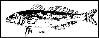
such as mullet (Mugilidae), bream (Sparidae) and whiting (Sillaginidae).
A distinctly different fish assemblage, dominated by the exotic
mosquito fish (Gambusia affinis) and Pacific blue-eye and
with only small numbers of commercial species, was sampled from
semi-permanent pools remaining after the marsh drained, but it
is not known whether this difference was due to the use of a different
collection technique (Morton et al. 1988). Juveniles
of economically important species such as barramundi were also
caught entering a creek supplying tidal water to a saltmarsh near
Darwin in tropical Australia (Davis 1988). Assemblages of fish
caught in permanent pools on the marsh flat differed from those
in the creek, with a relatively high number of juveniles of barramundi.
Again, it is not known whether this difference might have been
due to the different sampling method used. The studies cited above
of fish associated with saltmarshes indicate the beginnings of
an attempt during the mid 1980s to determine the importance of
marsh habitat, large areas of which were being degraded and destroyed.
Unfortunately no further work was done, even though the degradation
of saltmarshes continued.
Saltmarshes and saltflats constitute
approximately 22% of estuarine areas in Australia (Bucher &
Saenger 1991). There are no records of fish having been sampled,
anywhere in Australia, from the marsh flats which are inundated
during high tides but drain completely as the tide recedes, even
though they constitute the greater area of most saltmarshes. The
aim of this work was to determine whether fish use one such flat
in South Australian waters, and to compare differences in the
types and abundances of fish caught in creeks and any caught on
the flat.
Study site
The Barker Inlet - Port River
region is a marine-dominated estuary in the temperate waters of
South Australia. The estuary has very high abundances of juveniles
of commercially important fish species (Jones 1984) and so has
been declared an aquatic reserve. The ecology of fish within seagrass
beds adjacent to the marshes has been the subject of several surveys
and experiments (Connolly 1994a, b; Jones et al. 1996).
The present study centred on Torrens Island, which contains a
large proportion of the saltmarsh area within the estuary. Saltmarshes
constitute approximately 376 ha, which is 13% of the estuary area
(Bucher & Saenger 1989). The area of saltmarsh has been greatly
reduced by a combination of industrial and urban development including
salt evaporation pans and waste disposal sites (Brock 1975; Smith
1979). More than 75% of the estuary catchment has been cleared
of natural vegetation coincident with agricultural, industrial
and residential development north of Adelaide (Bucher & Saenger
1989).
The vegetation is typical of temperate
Australian saltmarshes (Adam 1990), being dominated by chenopod
shrubs (Sclerostegia arbuscula) and turf (Sarcocornia
quinqueflora). Mangroves (Avicennia marina var resinifera)
fringe the island seaward of the saltmarsh. Large numbers of striped
perch (Pelates octolineatus (Quoy & Gaimard)) and King
George whiting (Sillaginodes punctata (Cuvier & Valenciennes))
recruit into seagrass beds in the estuary early and late in the
autumn-winter period, respectively (Connolly 1994a).
Fish collections
To catch fish on marsh flats we
used a 3 x 3 m version of a buoyant pop net (Connolly 1994c),
used successfully in seagrass meadows and on mudflats (Connolly
1994b). The pop net consists of 4 fine-mesh (1 mm) walls pegged
to the seabed at the bottom and buoyant at the top. Mesh walls
are carefully folded and held under the plastic piping which forms
the top of the net. The whole structure is inconspicuous, lying
well hidden beneath the top of the low turf of Sarcocornia
quinqueflora, which was the dominant vegetation. The net is
held depressed to the sediment until released remotely, whereupon
the top of the net surfaces. On saltmarshes, erect vegetation
obstructs attempts to use a collecting net with a width the same
as the pop net (used in seagrass habitat, Connolly 1994c), and
we collected fish instead with a hand-held dipnet from the lowest
point in the sampling area, revisiting the net regularly until
the area was dry. The pop net differs from Rozas' (1992) lift
net in having no structures above the water near the site prior
to release.
Fish were sampled on 16 occasions
selected to coincide with the highest tidal peaks spread over
the autumn-winter period (April to July). Tidal peaks were greater
than the theoretical height of 2.95 m, and all occurred at night,
within 4 hours of dusk. One of two locations separated by almost
1 km of marsh was used on each sampling occasion, with each
location used alternately. Each location is supplied with seawater
and drained by two small creeks. Three pop nets were used to sample
fish from the inundated marsh flats on each occasion. Nets were
placed haphazardly with the closest edge 2 m from the creek,
and were released at the top of the tide, with water depths ranging
from 10 to 30 cm.
On each occasion fish were also
collected from within the creeks at the same location. One fyke
net was set in each of the 2 creeks at slack high tide, seaward
of pop net sites, aiming to catch all fish moving down the creek
on the ebbing tide. Fyke nets consisted of an 8 m long funnel,
with mouth width 2 m and height 0.84 m, and 1 m wide wings,
all of mesh 1 mm. The bottom of the wings and mouth were pegged
to the sediment surface, with no obvious gaps through which fish
could escape. All fish were identified and measured against a
ruler to the nearest mm (total length, tip of snout to tip of
tail). Water depth (cm) in the creeks at high tide was as follows
(measured at fyke net site, n = 8 for each creek): Location
A: Creek 1 mean = 75 (se = 5.4), Creek 2,
50 (3.3), Location B: Creek 3, 79 (6.0), Creek 4, 76 (4.9).
A comparison between fish densities
on the marsh flat and abundances in creeks can be made if the
marsh area drained by the creeks is known. The area inundated
on a given night differed with tidal height. We estimated what
we consider to be the average area drained by each creek, based
on site inspections and tracings from aerial photographs and orthophoto
maps (scale 1:2500). The shape of each drainage area was simplified
to a polygon, and was estimated to be: Location A: Creek 1, 7400
m²; Creek 2, 2470 m²; Location B: Creek 3,
2700 m²; Creek 4, 6890 m².
Water temperatures over the inundated
flats followed ambient air temperatures, and ranged from 23°
C in April to 14° C in July.
Results
Fish were caught in only 4 of
the 48 pop net releases, for a total of 19 fish of 2 species,
Glass goby and Small-mouthed hardyhead.
A total of 1109 fish of 6 species
were caught in 31 fyke net sets (one set failed) (Table 1).
The 2 species caught in pop nets were the most abundant species
caught in fyke nets. However, one additional species, blue-spotted
goby, was also present in relatively large numbers. One species
of economic importance, yelloweye mullet, was collected, but in
only small numbers.
A higher total number of fish
and greater abundance of the common species were caught at Location
A compared with Location B because of the higher abundances in
Creek 1 (Table 1). The total number of fish caught in Creek 1
was higher than in Creek 2 on every sampling occasion. Creek 2
had similar numbers to Creeks 3 & 4 at Location B even though
water depth in both these creeks was as deep as in Creek 1.
Abundances of common species showed
no obvious trend over the 3 months of sampling but all of the
yelloweye mullet (total 4) were caught at the first sampling occasion
at the 2 sampling locations.
In comparing fish densities on
the marsh flat with abundances in creeks we have pooled data from
both locations and all sampling occasions because of the infrequency
with which fish were caught in pop nets. The 1109 fish caught
in creeks came from a potential area of drained marsh of 148 240
m² (8 fyke sets in creeks 2-4, 7 in creek 1). If all fish
caught in creeks had been on the marsh flat prior to capture and
had been evenly distributed over the marsh, marsh flat densities
would be 1 fish/ 134 m². In fact the 19 fish caught in pop
nets came from a total of 432 m² (48 releases), giving 1
fish/ 23 m², a density about 6 times higher than expected.
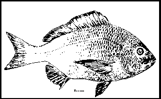
Table 1.
Summary of abundances (totals from 8 occasions in each case except
Creek 1 where the net failed on one occasion) and lengths (mm,
medians of all fish from a creek, incorporating all occasions,
shown in parentheses) of fish caught in creeks.
Species | Location A
Creek # | Location B
Creek # | Total both Locations |
1 | 2 | Total | 3 | 4 | Total | ||
| Gobiopterus semivestitus
Glass goby | 466
(23) | 32
(24) | 498 | 34
(23) | 2
(21) | 36 | 534 |
| Atherinosoma microstoma
Small-mouthed hardyhead | 213
(46) | 35
(42) | 248 | 73
(37) | 94
(43) | 167 | 415 |
| Pseudogobius olorum
Blue-spotted goby | 44
(43) | 69
(33) | 113 | 8
(30) | 25
(29) | 33 | 146 |
| Pseudaphritis urvilli
Congolli | 5
(81) | 0 | 5 | 1
(95) | 2
(105) | 3 | 8 |
| Aldrichetta forsteri
Yelloweye mullet | 1
(106) | 1
(133) | 2 | 1
(117) | 1
(135) | 2 | 4 |
| Pelates octolineatus
Striped perch | 2
(51) | 0 | 2 | 0 | 0 | 0 | 2 |
| All species | 731 | 137 | 868 | 117 | 124 | 241 | 1109 |
| Number of species | 6 | 4 | 6 | 5 | 5 | 5 | 6 |
Discussion
This is the first record in Australia
of fish being captured on a saltmarsh flat inundated at high tide
but emergent at low tide. Species richness was low on the marsh
flat relative to that in the creeks, but this may be due simply
to the relatively small area of marsh flat netted. Species taken
commercially or recreationally were represented only by a very
small number of yelloweye mullet caught in the creeks but not
on the marsh flat. No early juveniles of the most economically
important species in the estuary, King George whiting, were caught
during this study, even though they were being caught in seagrass
beds adjacent to the marsh in June and July of 1993 (Connolly
unpublished data). Only two trumpeters were caught (and these
in a creek), despite this species being abundant in adjacent estuarine
waters in autumn (Connolly 1994a).
Although the total number of fish
caught on the marsh flat was small, more fish were caught there
than would be expected from the number caught in creeks. One or
more of the following possibilities could account for this: 1)
fish on the marsh flat at high tide were more abundant near creeks
rather than being evenly distributed over the flat, 2) fish in
creeks escaped capture by fyke nets, 3) pop nets caught more fish
than occur on the flat when no netting takes place (e.g. fish
might be attracted to pop net locations because of disturbances
to sediment whilst setting nets). The data do not point to pop
net catches underestimating fish densities on the marsh flat,
but the efficacy of the pop nets in the very shallow waters on
marsh flats cannot be confirmed without further work.
Results of the present study are
not necessarily applicable to other regions, especially those
with less obvious anthropogenic influences. Even on Torrens Island,
abundances might fluctuate with season, for example, since juveniles
of several other commercial species are present in the estuary
during the warmer months of the year. Given the limited temporal
and spatial scope, results presented here should be seen as preliminary
work for a more thorough sampling procedure.
The value of the present study
lies in giving an indication of the density of fish found on the
inundated marsh flat on Torrens Island, and in a demonstration
of the use of a buoyant pop net in marsh habitat. To understand
the role of saltmarsh as fish habitat, future work should attempt
to determine the relationship between fish abundances and different
tidal heights, distances from creeks, levels of prey availability,
vegetation types and climates. This information should be brought
together with results from studies in adjacent mangrove forests
and mud flats.
Acknowledgements
This work was assisted by Martine
Kinloch, Karen Edyvane (SARDI - Aquatic Sciences), Bob Ainslie
(ETSA), Doug Fotheringham (SA Dept of Environment), Terry Sim
(South Australian Museum) and Barry Bruce (CSIRO). This article
includes results reported in the Australian Journal of Ecology.
References
Adam P. (1990) Saltmarsh Ecology. Cambridge University Press, Cambridge.
Brock B.J. (1975) The decline of the estuarine commons near Adelaide. Operculum 4, 90-95.
Bucher D. & Saenger P. (1989) An Inventory of Australian Estuaries and Enclosed Marine Waters. V - South Australia. Centre for Coastal Management, Northern Rivers College of Advanced Education, Lismore.
Bucher D. & Saenger P. (1991) An inventory of Australian estuaries and enclosed marine waters: an overview. Australian Geographical Studies 29, 370-81.
Connolly R.M. (1994a) A comparison of fish assemblages from seagrass and unvegetated areas of a southern Australian estuary. Aust. J. Mar. Freshwat. Res. 45, 103344.
Connolly R.M. (1994b) Removal of seagrass canopy: effects on small fish and their prey. J. Exp. Mar. Biol. Ecol. 184, 99-110.
Connolly R.M. (1994c) Comparison of fish catches from a buoyant pop net and a beach seine net in a shallow seagrass habitat. Mar. Ecol. Prog. Ser. 109, 305-9.
Davis T. L. O. (1988) Temporal changes in the fish fauna entering a tidal swamp system in tropical Australia. Env. Biol. Fish. 21, 161-72.
Gibbs, P.J. (1986) The fauna and fishery of Wallis Lake. In: Wallis Lake: present and future. pp. 1-7. Australian Marine Science Association, NSW
Jones G. K. (1984) The importance of Barker Inlet as an aquatic reserve; with special reference to fish species. Safic 8, 8-13.
Jones G.K., Baker J.L., Edyvane K. & Wright G.J. (1996) Nearshore fish community of the Port River - Barker Inlet estuary, South Australia. 1. Effect of thermal effluent on the fish community structure, distribution and growth of economically important fish species. J. Mar. Freshwat. Res. 47, 785-99.
Kneib R.T. & Wagner S.L. (1994) Nekton use of vegetated marsh habitats at different stages of tidal inundation. Mar. Ecol. Prog. Ser. 106, 227-38.
Morrisey D. (1995) Saltmarshes. In: Coastal marine ecology of temperate Australia (eds A. J. Underwood & M. G. Chapman) pp. 205-20. University of New South Wales Press, Sydney.
Morton R.M., Pollock B.R. & Beumer J.P. (1987) The occurrence and diet of fishes in a tidal inlet to a saltmarsh in southern Moreton Bay, Queensland. Aust. J. Ecol. 12, 217-37.
Morton R.M., Beumer J.P. & Pollock B.R. (1988) Fishes of a subtropical Australian saltmarsh and their predation upon mosquitoes. Env. Biol. Fish. 21, 185-94.
Rozas L.P. (1992) Bottomless lift net for quantitatively sampling nekton on intertidal marshes. Mar. Ecol. Prog. Ser. 89, 287-92.
Smith D.L. (1979) Landuse and Groundwater History of the Northern Adelaide Plains. Department of Geography, University of Adelaide, for Engineering and Water Supply Department of South Australia, Adelaide.
Talbot C.W. & Able K.W. (1984)
Composition and distribution of larval fishes in New Jersey high
marshes. Estuaries 7, 434-43.
Here in South Australian waters, just off the coast of Adelaide, there are many, many different species to be found. A great deal of these species can be found nowhere else in the world. Yet there is no public showcase or public aquarium to show off these magnificent creatures. In the following essay it will be shown why we, as South Australians, need a public showcase.
More than 85% of all marine life found off South Australia's coast can not be found anywhere else in the world. Many South Australians do not know of this and do not appreciate it as much as those who do know just how precious the coastal area of South Australia is. If a marine exhibit is set up more people would become aware of these animals and plants, and how precious the coastal areas are.
A marine exhibit would show the rest of the world's scientific community what a vast array of different species are here in South Australia. This would cause great interest in the area scientifically and also attract tourism from divers. It would put South Australia as a place to research for quite a lot of marine biologists.
This kind of exhibit here in South Australia could promote marine biology to young people as an interesting career opportunity, improving the amount of young people coming into the community (scientific). It would also help school teachers by being able to take students there and show them what they had been talking about.
A great interest in protecting the coastal area would also occur. Money from the exhibit could be used to help protect the marine environment off our coast. Enabling future generations to enjoy these species for many years to come.
An exhibit could create a boost in the local economy from the tourism dollars, and the scientific dollars because of the exhibit. This would create many jobs.
Many biologists would benefit
from an exhibition, this would give them easy access to information.
On different phylum, species, etc, etc,. Information could be
easily set up like this, giving biologists easy access to valuable
information.
In conclusion a Marine showcase
would greatly benefit the South Australian community, the scientific
community and tourists as well. There are only positives for a
marine showcase and there are no negatives.
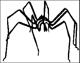
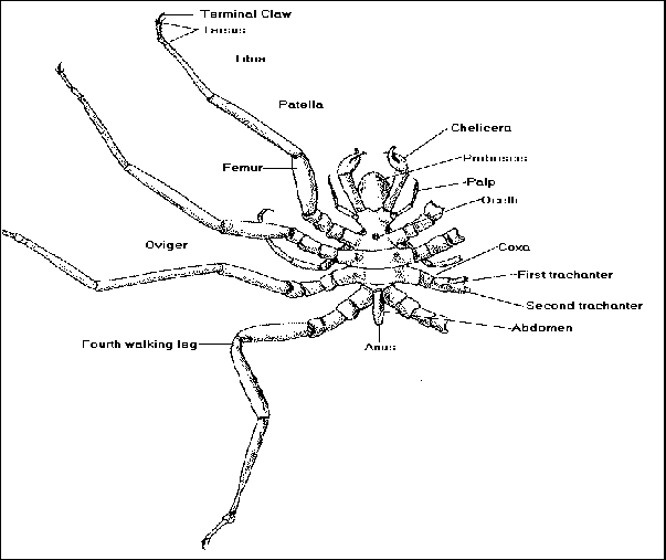
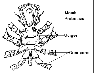
Sea spiders belong to Phylum Arthropoda and are accepted as an independent class of the Chelicerata.
In the great group of chelicerates are included a variety of "arachnoid" types, most of which are in highly specialized terrestrial groups. Both Pycnogonids and Chelicerates have claws on the first appendages and a tubercle with simple eyes, and both lack antennae. However, pycnogonids show so many unusual features, such as the proboscis, reduced abdomen, ovigers, gut diverticulae, and so on, that they may comprise a separate group that probably branched off very early from the arthropod stem.
Pycnogonids, or "sea spiders",
are among the most bizarre-looking arthropods. There are approximately
50 genera, with between 500 and more than 1000 known species.
They can be found from the intertidal regions to depths of around
7000 m. Most are small, but a few deep-sea forms reach up to 70
cm diameter across the legs. They are carnivorous animals that
suck out the juices of their prey. Sea spiders are more common
in the cold Arctic and Antarctic seas than they are elsewhere,
although they are found in all seas. Most sea spiders live near
the shore, crawling around on the surface of animal colonies or
sea-weeds. They rarely crawl far but slender forms can use water
currents to rise and drift in the water column for long distances,
regulating descent by folding their legs.
Another name sometimes used for
them, Pantopoda, means "all legs" and describes them
perfectly. Pycnogonids have extremely reduced bodies in which
the abdomen has almost disappeared, while the relatively long,
hinged legs are clawed and consist of eight segments. The body
itself is not divisible into neatly organized tagmata or regions
as it is in most other arthropods. Typically, the sea spider head
has two pairs of simple eyes on a central tubercle. Unique characteristics
include an unusual proboscis, which varies in size and shape among
species, but amounts to a chamber with an opening at the distal
end (the true mouth lies between the proboscis chamber and the
esophagus) and three pairs of appendages. The elongated trunk
of the sea spider has four segments, each with a pair of long,
jointed legs. The first pair of appendages hold food and clean
the mouth. The second pair of appendages has leg-like functions.
The third pair (ovigers) is specialized in the male to carry egg
masses.
These it takes from the female and cares for until they hatch. They are also used in cleaning. Their sexual organs, either testes or ovaries, extend onto their legs due to the lack of space within their bodies. A terminal segment includes a tubercle that projects dorsally and an anus.
Some species have more than four pairs of walking legs. Dodecolopoda mawsoni, which is found in Antarctic waters is notable for the fact that it has six pairs of legs and may grow in excess of 40 centimetres across. Pycnogonids are also unique in bearing multiple gonopores, found on the second segment of some or all of the walking legs.
The abdominal segment, sometimes fused with the head, is little more than an alimentary canal. The sea spider's digestive system extends into the Pycnogonids feed on soft-bodied invertebrates, in particular cnidarians, sucking at them with their probosces. Razor sharp pincers called chelifores are used to cut the food into pieces which is then sucked up. The feeding tubes inner surface is lined with an array of sharp spines which further slices up the prey. Larval Pycnogonids often live as parasites within cnidarian tissues. The intestine of Pycnogonids has extremely long diverticulae (blind pouches) that extend to the ends of the legs.
When mating, some species have been observed clambering onto the back of the female and then over her head to the underside. Positioned head to tail the male collects the eggs as they are laid. Cement secreted from glands in the legs assists the male to hold the eggs in position. The eggs are carried by the male until the well developed young hatch. Many young stay with the father until they reach an advanced stage of development.
Pycnogonids have almost no fossil record. Three genera have been found in the Devonian period, in the Hunsruck State of western Germany.
Selected Bibliography
Introduction
For this negotiated topic, I have chosen to do some research on sharks and why they are decreasing in numbers. I will also look at the protection of sharks.
I have chosen this topic because I think sharks are fascinating creatures. My brother has a very good non-fictional book all about sharks and there are some interesting facts. I also read about shark attacks and the victims' stories and their experiences. I found this part very interesting, especially the story about Rodney Fox.
Society needs to be educated and
become environmentally aware of our sharks' decreasing number.
Sharks have a right to survive just like we do.
The Article
This article is aimed at the general public to encourage people to be more environmentally aware about the need for protecting our sharks.
Sharks have lived on the earth for a very, very long time. They existed before the first human beings and scientists believe that they prowled the oceans more than 350 million years ago.
Sadly, in today's society, our sharks are under attack and are on their way to becoming endangered, all because of us. Humans have developed many powerful weapons to kill sharks. Strong rods, lines and special hooks made of stainless steel are used by anglers. Fishermen use nets and harpoons. Spearguns and powerheads loaded with shotgun shells are used by divers.
The obvious reason why people kill sharks is because they are scared of them. Shark attacks have been exaggerated and blown out of proportion by media reports and such films as "Jaws". People believe they are dangerous to swimmers and divers and therefore must be killed without any thought of the effect on the environment. Today's society needs to be educated, and it needs to be known that there are about 370 species world wide potentially dangerous to humans, and only about four species which cause fatal attacks. Most sharks don't cause any harm at all. More people die by bee stings or lightning strikes each year than through shark attacks. Considering the amount of time we spend at the beach compared to being in a storm, the risk of being attacked by a shark is very low. No doubt some shark attacks occurred because the shark was being encouraged.
Many sharks are caught in the safety nets outside beaches and die because they cannot move. Other sharks get tangled up in ropes, plastic straps and other rubbish that we throw into the sea.
The number of sharks is decreasing at a much faster rate than ever before. We know very little about them and don't even know exactly how many different species there are.
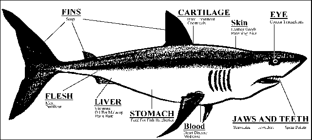
Another reason why sharks are in danger of becoming endangered is because people are catching and selling them for a lot of money. Their meat is eaten or used for fertiliser. Their oils are used for vitamins, lubricants and cosmetics. Shark teeth and jaws have been used for centuries to make jewellery and weapons. Shark skins are used for making leather goods. Their eyes, blood and cartilage are often used in medical treatment and research.
Sharks need to be protected because they are a valuable resource to scientists and the medical industry. The latest research proves that their fins contain a special kind of cartilage which can prevent cancerous tumours. Sharks are the only animals which have been found to never have cancerous tumours. This brings us a step forward to preventing cancer in humans and maybe even curing it.
In addition, sharks are an
important link in the food chain on this planet.
If sharks become extinct, then the food chain would not be balanced.
People must share the planet with many living things, including
sharks. The more we learn about sharks, the better off we will
be and the safer sharks will be.
NOTE
Underlined sentences are "true"
facts or statements.
BIBLIOGRAPHY
1. Readers Digest
- 1989. Sharks-silent hunters of the deep. Published by Readers
Digest Pty. Ltd. Australia.
2. Southern Fisheries - Winter 1993 - The Shark Debate. Volume 3. Number 2.
Published by the Department of Primary Industries - Fisheries and the S.A. Research and Development Institute -Aquatic Sciences.
Published in Adelaide.
3. The Advertiser -
Thursday, March 17th, 1994. Monster Shark a World Beater.
Adelaide.
4. Walker, Kerstin -
1987. The World of Sharks. Published by Wayland Publishers Ltd.
England.
The amount of sea grasses around Australia is decreasing rapidly, especially in St Vincent Gulf.
We need to protect our sea grasses because they play an important role in our environment. They hold the sand in place with their roots and provide protection against storms and strong currents. Without them, Australia would turn into a desert because all the sand would erode. Sea grasses also provide a safe habitat in our marine environment from predators. If the sea grasses were gone, then so would the fish who hide in amongst the sea grass because they would be homeless or eaten.
In addition, small fish which are valuable to our fishing industry hide amongst our sea grasses - such as tuna. We would only be putting ourselves at a disadvantage if we got rid of sea grasses so there would be no tuna.
The reason why our sea grasses are disappearing is because we let out sewage, storm water and other pollutants into our sea. However, this is not what is killing them. On sea grasses live epiphytes which feed on the sewage, storm water or other pollutants. Because they are receiving a great meal and there is lots of it, they reproduce and more epiphytes live and breed on the sea grasses until they form a thin layer over the top of the sea grasses, completely covering them. As a result, it blocks out all the sunlight which the plants need to photosynthesise and so they therefore die.
As you can see from my discussion,
sea grasses are a valuable resource to our environment and should
be kept. They play an important role and we should find some other
way of getting rid of our sewage and other pollution.
Mediterranean sea worms are a destructive worm that have recently been found in South Australian waters. This has aroused fear over the future of the State's multimillion dollar shellfish industry. The sea worm (Sabella spallanzanii), kills shell fish by smothering them. They have destroyed scallop fishing enterprises in Victoria's Port Phillip Bay.
The South Australian Museum has collected six of the worms that were found on a pontoon at West Lakes, and have identified them as the European species. The manager of the Museum's marine invertebrates collection, Ms Karen Gowlett-Holmes, said "It was the first report of the worms in South Australian waters". The worms were probably transported to S.A. either on ships' hulls or in their ballast water.
Mediterranean sea worms grow to about 40cm. The worms colonise quickly and then smother and displace other marine life such as Mussels, Oysters and Scallops. The worms live inside a hard green tube, and attach themselves to rocks, pylons and shells so they can filter microscopic food through long filaments.
Ms Gowlett-Holmes said that "The tubes stick together forming large mats which can completely cover a surface, stopping anything else growing there". She also said that if they got into the oyster farms at Coffin Bay they could cause a major problem for the growers.
If the farmers at Coffin Bay lose most, if not all, of their stock they would lose a lot of money. The decrease of oysters on the market would mean an increase in the prices.
The worms have very few natural predators in Australian waters because fish find the worms unpleasant to eat, so once the worms are established they are very difficult to remove.
Because the worms have very few natural predators they could wipe out the seas shell fish species. This would make the shell fish a rare and endangered marine species.
If the infestation at West Lakes was large authorities might have needed to put additional restrictions on ships moving between South Australian ports.
Tasmanian marine expert for the CSIRO, Dr Sebastian Rainer, said the sea worms were first discovered in Australia near Geelong ten years ago, and had reached densities of 100 a square metre in parts of Port Phillip Bay.
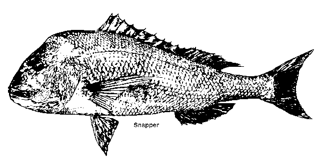
Snapper fishermen's long lines were getting entangled in the worms and scallop trawlers were hauling up large mats of them in their nets. The worms were also found at many locations in south-west Western Australia, and were being studied to determine their range and any possible means of controlling them.
In September 1994, large beds of Sabellid worms were found in Cockburn Sound, Western Australia, by university students, Geordie Clapin and Ed Greenway during a collaborative study between the CSIRO Division of Fisheries, the West Australian Department of Environment Protection and the Edith Cowan University.
Geordie Clapin was awarded a nine-week CSIRO Vacation Scholarship to conduct a study on Sabellid worms which were classed as a marine pest.
Before the worms are sexually mature they have to be at least 15cm long. The sex of the worms also depends on how long they are, it was found that the worms between 15 and 20cm were male and all those over 30cm were female. The male:female ratio of worms between 25 and 30cm was 1:1. According to Giangrande and Petraroli this variation strongly indicates that the S. spallanzanii are protandric hermaphrodites.
Bibliography
In 1969, M. Blumer estimated that 0.1% of all total oil transported is spilled into marine waters, as crude oil or petroleum products. Blumer made these comments in the publication "Oil on the Sea" edited by D.P.Hoult (Plenum Press, New York). This reference comes from the December 1979 paper "Marine Reserves in South Australia: Proposals for some future directions" by Ottaway, Oak, Bossley & Gardiner. The authors estimated that hundreds of thousands of litres of oil could have spilled into the water at Port Stanvac refinery in 1979.
Ex MP Dr Don Hopgood estimated that at least eight oil spill incidents occurred at Port Stanvac refinery between 1977 and 1981. In 1996 Tony Flaherty from the Marine & Coastal Community Network wrote that between 1973 and 1986 272,000 litres of oil was spilled in 80 incidents in SA waters. He also said that in a 42 month period between January 1988 and June 1992 8,610 litres of oil were spilled in 14 incidents.
Our state's worst oil spill occurred on 30/8/92 when 296 tonnes of heavy engine fuel oil from the tanker ERA was spilled at Port Bonython. The resulting slick drifted into the Port Pirie mangroves which are fish breeding grounds. Society member Rod Connolly has been studying the effects of the spill on fish communities in the mangroves. A report by Rod (& G.K. Jones, 1996) - "Determining effects of an oil spill on fish communities in a mangrove-seagrass ecosystem in southern Australia" - is in press at present. Rod gave his permission to us to present the following paragraph in this article:-
"Fish associated with mangrove-lined creeks were surveyed using fine-mesh seine nets inside and outside a section of coast contaminated by an oil spill from the "Era" vessel in Spencer Gulf, South Australia, in August 1992. At two sampling periods (3 and 6 months after the spill) fish assemblages at each tidal creek were found to be distinct and assemblages from creek entrances were different to those from within creeks at one period. No differences between assemblages inside and outside the oiled section of the coast could be detected, even though the study design and statistical analyses should have been able to detect any sizeable impact of oil on fish communities. Abundances of economically important species were not consistently different inside and outside the oiled area, although they differed among creeks. Juveniles of several economically important species were significantly smaller in oiled creeks than in unoiled creeks, raising the concern that oil retarded growth rates."
Last year Messenger Press suggested that 18 oil spills had occurred at Mobil's oil refinery at Port Stanvac between 1987 and November 1997.
We have some information in our Society library about a fish-kill in December 1980. Dr John Ottaway from Flinders University thought that a spill of almost 8,000 L of crude oil at Port Stanvac refinery was to blame but the State Government disagreed. Over 11,000 L of dispersant was used on the spill.
Some 15,000 L of toxic Copper Chromium Arsenate entered the North Arm of the Port River in September 1985 after leaking into a canal at Gillman. Our Society became involved in the public uproar over this incident and our library contains details of the event.
In September 1991 a 22km long slick was found near Troubridge Island in Gulf St Vincent. An aircraft was used to drop chemical dispersant on it.
Another spill of toxic Copper Chromium Arsenate leaked into creeks that channel into the Patawalonga, apparently killing off fish, in February 1992.
The August 1992 spill of about 300,000 L of heavy bunker oil at Port Bonython occurred just six weeks after a chlorine leak at the Thomas Playford power station at Port Augusta had killed thousands of fish in upper Spencer Gulf. 350kg of chlorine leaked from a ruptured pipe on 7/7/92.
Three oil spills were reported at Port Stanvac refinery in 1992. One of the spills caused a large fire. Another spill (400 L) caused a slick several metres long and extending 1km out to sea. Another spill was said to be 100 L but the Surfrider Foundation claimed that the quantity was more like "300 times the publicised amount".
In November 1992 600 L of diesel fuel escaped from a ruptured hose on an oil rig anchored 20 nautical miles south-west of Glenelg.
In December 1995 ETSA said that in the three years between January 1993 and December 1995 they had oil enter the water eight times when drainage systems overloaded. The amount spilled was less than 2 L on six of these occasions but in December 1995 2,000 L was spilled into Angas Inlet when a transformer ruptured.
In September 1996 Port Stanvac refinery reported that light crude oil was spilled from a split in a 500m long floating, high tensile ship-to-shore hose either during unloading or during a safety check. The amount of oil first reported as spilled was just 20 L but this was later revised to 100 L. The normal procedure when such a leak is detected is to remove the tanker from the mooring buoy and decant the remaining oil in the hose and have it barged ashore. It was decided, however, to flush the hose clear with water. This action caused a much greater spill than what would have occurred if normal procedure had been followed. The decision to flush the hose was made between the refinery, the Department of Transport and the EPA. During the flushing oil from the hose shot 8m-high for 14 minutes. This caused the forecastle of the tanker to be abandoned. In February 1998 State Parliament was told that this caused between 40,000 and 140,000 L of oil to be lost. Oil from the spill was reported to have covered reefs an beaches from Port Stanvac to Seaford. When the EPA first investigated the incident it declared that over 10,000 L of oil (not 100 L) had spilled into the ocean. It promised to release a report on the spill and, if possible, prosecute those responsible for it. The EPA referred the matter to the Crown Solicitor's office with the recommendation to prosecute Mobil for environmental damage. At this stage, however (over seventeen months later), there has not been any action taken over the case. The report on the EPA's investigation is still awaiting deliberation. Companies can be fined up to $1m under State law for serious environmental damage and individuals can be fined up to $250,000 or face four years in jail.
In July 1997 an oil spill caused three separate slicks near Port Lincoln. The three slicks were each estimated to measure about 500m by 60m. The Transport Department believed that the oil had been deliberately pumped from a vessel such as a fishing boat. An analysis of the slicks suggested that a small vessel had pumped its bilge water into the sea.
In the week leading up to this spill, penguins, cormorants, cuttlefish, leatherjackets and pufferfish were being washed up dead along the east coast of the Eyre Peninsula but the authorities said that the deaths were not connected with the oil spill.
Port Lincoln's tuna fishermen said that a spill has the potential to cause their industry major problems.
In August 1997 an estimated few hundred litres of oil contaminated the Greenfield wetlands at Salisbury. It is thought that the oil had seeped into the soil at the Bridgestone plant at Salisbury South. Heavy rains and a rising water table may have flushed oil from the soil into a cracked stormwater pipe. The oil entered stormwater drains leading to the wetlands. Surface oil was stopped from entering the sea by a boom strung across the Barker Inlet.
In November 1997 an unknown quantity of light crude oil was spilled at Port Stanvac. A 3mm crack in the hull of the Malaysian charter vessel MT Bunga Kertas was found following the discovery of a leak before unloading began. The ship had been 3km offshore when the leak was discovered. It was then taken 8km offshore where wind and tide helped disperse the oil. The EPA said that environmentally sensitive areas such as Port Noarlunga Reef and the Onkaparinga Estuary had not been affected by the spill which posed no real threat. Mobil said that patches of oil were identified within a 400m radius of the ship.
More than 60 tonnes of bunker oil was spilled into the Port River on 4th February 1998. The oil was spilled from the container ship MSC Edna which was docked at Outer Harbor's No. 6 container berth. Boats from the Royal South Australian Yacht Squadron could not leave their moorings until the oil spill had been cleaned up. Members of the squadron helped personnel from the Metropolitan Fire Service, Ports Corporation and Transport SA Oil Spill Emergency Response Team to clean up the spill from the basin and shoreline. The oil spill was contained by booms and sucked up by skimmer machines. Over 60 tonnes was mopped up on 5th February and the clean up took about four days altogether. Emergency service workers used high pressure hoses to dislodge oil from rocks near the Royal SA Yacht Squadron. Marine safety officers from Transport SA and Ports Corp were to investigate the cause of the spill. It was thought that the oil was expelled from the MSC Edna whilst pumping out water.
Small spills occur regularly. For example, in November 1996 a minor spill occurred at the inner harbour when the HMAS Brisbane visited Port Adelaide. In two separate incidents in 1997, boats hit the Outer Harbor breakwater and sank.
On 1/9/97 a small slick occurred near Granite Island, Victor Harbor when about 15 L of diesel was spilled from an unknown vessel. Choppy seas and windy conditions helped to disperse the diesel and apparently no animals were affected.
In April 1998 the fishing vessel Southern Star capsized and sank at its moorings in the Port Lincoln marina with 7,500 L of diesel on board. The diesel had started to leak into the water by the time that the Metropolitan Fire Service had arrived. Floating booms were placed around the escaping oil whilst ways to right the ship were investigated.
In its Annual Report for 1996/7 the EPA says that during that period it dealt with more than 70 emergency pollution incidents. Transport spills caused 30% of incidents whilst marine and industrial spills each caused about 20% of all emergency calls.
I have entered much of the above
information about oil spills into a data base for future reference.
Although the figures are either estimates or incomplete I calculate
that between 1973 and 1996 there were at least 108 oil spill incidents
involving at least almost 600,000 L. This does not include any
figures for 1987 at all. At least 6 incidents occurred between
November 1996 and November 1997 but no amounts of oil have been
reported. The EPA's record of emergency calls for 1996/7 suggests
that there were about 14 marine incidents during that time. Major
incidents handled by the EPA during those twelve months include
a Port Stanvac oil spill, detergent from a road tanker at the
bottom of Mt Barker Road draining into the Patawalonga and a large
amount of indigo dye from a dry cleaning company spilling into
Keswick Creek.
Large oil spill cleanups usually involve the use of large amounts of chemical dispersant. For example, in the 1980 spill of 8,000 L of crude oil at Port Stanvac refinery over 11,000 L of dispersant was used.
Dispersants in the past have been largely Ethylene Glycol Monobutyl Ether and they possibly did more harm to the marine environment than oil spills themselves. The dispersant used at Port Stanvac in 1980 was said to be of low toxicity though. Hopefully dispersant manufacturers are continuing to develop safer dispersants with lower toxicities.
Other products and methods are being developed for the fight against oil spills. The use of bacteria to transform toxic oil into harmless fatty acids (bioremediation) was first reported in our September 1990 Newsletter (No.158). Our March 1991 Newsletter (No.164) mentioned the use of high strength bags for collecting oil spilled at sea. (An article from The Advertiser about oil spills also appeared in this issue of our newsletter.)
Articles in both our May 1991 Newsletter (No.166) and October 1991 (No.171) described bioremediation in more detail.
Our June 1992 Newsletter (No.179) included an article from The Advertiser about the use of natural fibres to clean up oil spills. Fibres from plants were found to act like sponges and soak up more oil than synthetic mats that had been used in oil spill emergencies.
Our 1992 MLSSA Journal (No.3) reported the development of a product that cleaned structures of both fresh and weathered oil without dispersing or emulsifying the oil, allowing it to be washed into the water and picked up with skimmers.
That same Journal also reported the use of natural fibres to clean up oil spills. It was Grabol, an absorption material made of plant material with a lipophilic substance added. The material was enclosed in cotton mesh and was 100% biodegradable.
Our February 1993 Newsletter (No.186) reported the efforts of several Australian companies to rid dispersants and other chemicals of marine toxins.
The November 1993 Newsletter (No.195) reported the local discovery of a polymer compound which turns oil into a gel. It can prevent oil from spreading, thus preventing environmental damage. It could also seal ruptured tanks in emergencies. It will gel at least 30 times its own weight, reducing the risk of fire or explosion. It can easily be manually cleaned up.
In 1997 we heard about scientists
in Adelaide testing a new product in the battle against oil spills.
Australian clay was being finely ground into a powder which causes
floating films of oil to form into clumps. Bentonite clay is chemically
modified to repel water but attract oil. The small clumps that
form from films of oil can be mopped up easily. Clays are non-toxic
and have a very large surface area for their weight. Australia
has large deposits of bentonite clay. Spills could be sprayed
from the air with bentonite clay powder. It would be a natural
and cost-effective method for fighting spills if it proves to
be commercially successful.
Further Reading
"Pollution and Conservation in Australia" (A layman's guide to the causes, effects and controls of pollution) by Dr Angus Martin (1973) Lansdowne Press, Chapter 5 "The Oceans".
"Pollute and be damned"
by Arthur Bourne (1972) JM Dent & Sons Ltd, Chapter 8 "The
familiar sea & other stories".
The polymer compound was discovered by Dr Jani Matisons, a scientist from The Levels.
Grabol had been in use in Australia
since 1985. It was manufactured by Aust-Pol Engineering in Sydney
and it was available in Adelaide from Petroleum Consulting.
ish associated with mangrove-lined creeks were surveyed using fine-mesh seine nets inside and outside a section of coast contaminated by an oil spill from the "Era" vessel in Spencer Gulf, South Australia, in August 1992.
At two sampling periods (3 and 6 months after the spill) fish assemblages at each tidal creek were found to be distinct and assemblages from creek entrances were different to those from within creeks at one period.
No differences between assemblages inside and outside the oiled section of the coast could be detected, even though the study design and statistical analyses should have been able to detect any sizeable impact of oil on fish communities.
Abundances of economically important species were not consistently different inside and outside the oiled area, although they differed among creeks.
Juveniles of several economically
important species were significantly smaller in oiled creeks than
in unoiled creeks, raising the concern that oil retarded growth
rates.
This essay shall be on the topic
of Marine Protected Areas, and how since making the areas protected
it has benefited, as well as for humans and our society.
Since making many areas down south
protected marine areas, many natural sea creatures have returned
to those areas with the biggest example being whales (literally
the biggest).
Our southern coasts are natural
breeding and mating grounds for whales in the Winter.
There used to be whaling stations set up, like on Kangaroo Island, but now that they are closed and it is forbidden to kill the creatures down there, many have returned and in greater numbers too.
It has benefited the Southern Right Whale population and has also benefited the S.A. economy as it is now a tourist attraction to go "whale watching" with tours being taken and merchandise being sold such as hats, T-shirts, mugs, etc.
Now Whale Watching Centres are
starting to appear with much needed information and education
about these beautiful whales and not just the Southern Rights.
Other creatures have benefited
also from areas becoming protected. Drag net fishing was common
in some areas, and it managed to damage ecosystems by killing
animals that didn't need to be killed. Now with most of those
fishing practices banned as well, food chains are repairing themselves.
In conclusion you must admit that
all places zoned off for marine protection benefit from the isolation
from humans. I think a lot more places should be zoned off and
not just from fishing or tourists, from pollution, sewage dumping,
oil tankers, mining, nuclear testing and any other such possible
damage that we humans cause to the environment.
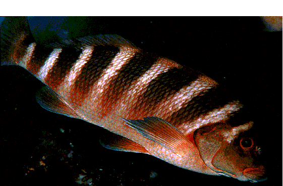
The Banded Morwong (Cheilodactylus
spectabilis) also known in Australia as the Brown-banded Morwong,
is a common fish in Victoria, southern NSW and Tasmania and is
also found in New Zealand.
It is a robust Morwong with distinctive
marking comprising 7-8 evenly spaced broad, dark brown, roughly
vertical bands, growing to about one metre and 15kg in weight,
generally found on higher wave-energy rocky reefs. Rudie Kuiter
in "The Complete Diver's and Fisherman's Guide to Coastal
Fishes of South-Eastern Australia" states "examination
of otoliths in large specimens in New Zealand suggest an age of
about 60 years." It is pursued by spearfishers but rarely
taken on hook and line and is said to be moderately good eating.
This article aims to document
a more westerly distribution for this species than is recorded
in the currently available reference books for Southern Australian
marine fishes (Appendix1), and to then briefly comment on this
observation.
Having dived SA waters for many
years I was surprised to see, towards the end of a dive at Seal
Rocks, (east of Snug Cove on Kangaroo Island's north coast) on
30/04/89, a sizeable reef fish quite distinct from any I'd seen
before, investigating my presence at approximately 15 metres depth
on a heavily algae-covered sloping rocky reef.
This was my third dive trip to this area in as many years but the first time I'd seen this species. Yet I have since seen Banded Morwong on every weekend dive trip I've done to this area ie 11/89, 10/91, 11/93 and 12/94. I was able to identify the species readily that evening from two books, both of which gave it's most westerly range as Robe, S.E. South Australia. I was only mildly surprised by this, both because knowledge of species' ranges along our sparsely populated southern coastline is sketchy at best, and because even fewer divers explore the northern Kangaroo Island coastline than mainland sites.
Subsequent sightings were also confirmed by MLSSA secretary Steve Reynolds, who dived with me in November '89 at Seal Rocks.
The largest specimen I have encountered
on Kangaroo Island would have been about 70 cm long and weighed
5-6kg. The fish favoured deeper aspects of the reef particularly
larger caves on drop-offs close to the cliff face, and one pair,
probably mates (one large and one somewhat smaller) had a territorial
"beat". They would (at times singly and at other times
in loose association) swim a circuit which involved passing right
to left across a large flat cave, disappearing out of the shallower,
left-hand extremity and within 15 seconds or so, reappearing at
the deeper right-hand extremity. Theoretically this should have
facilitated my photographic efforts, however, these fish were
strong, restless swimmers which, although quite bold and inquisitive
when ignored, never slowed during their energetic swim-bys and
would quickly deviate from their course once they perceived a
diver with a camera swinging towards them. This resulted in a
number of mediocre exposures, in which the fish could nevertheless
be clearly identified. Perusal of the available books (Appendix
1) has failed to disclose any record of this species for Kangaroo
Island.
Interestingly, two other SA Morwongs,
the Dusky Morwong (Dactylophora nigricans) and Magpie Perch
(Cheilodactylus nigripes) whilst far from rare on Kangaroo
Island, appear less common here than at similar sites on the mainland,
where they are prolific and it may be that the Banded Morwong
partly displaces these species on Kangaroo Island's north coast.
The Southern Blue Morwong (Nemadactylus valenciennesi)
often known locally simply as the Blue Morwong, is reasonably
common along the northern Kangaroo Island coast but seems to be
somewhat less territorial than the Banded Morwong.
Of SA's remaining known Morwong
species, the Jackass Fish (Nemadactylus macropterus) is
a deep water fish rarely seen by divers, whilst the Redlip Morwong
(Cheilodactylus rubrolabiatus) is only recorded west of
Ceduna.
I have done no oceanic diving
in the south-east of our state so I cannot comment on the prevalence
of the Banded Morwong in our south-eastern waters but I have never
seen any on numerous dives to similar depths over many years on
the western Fleurieu Peninsula, nor heard of any sightings by
other divers in this region. I therefore suspect that the Banded
Morwong does not occur in these slightly warmer, calmer mainland
gulf waters adjacent to northern Kangaroo Island, although conditions
on the eastern Fleurieu coastline (eg Victor Harbor) would seem
favourable to this fish due to the larger swells and it may yet
be discovered there.
Taken as a group, South Australia's
Morwongs figure prominently in diver fish sightings and with the
possible exception of the rather drab Dusky Morwong, are quite
attractive fish.
I look forward to further encounters
with Cheilodactylus spectabilis in particular, so that
I can add a better portrait to MLSSA's Photo Index.
Gammon, Glover and Kuiter: "The Fishes of Australia's South Coast" (1994).
Hutchinson and Swainston: "Sea Fishes of Southern Australia" (1986).
Kuiter: "The Complete Diver's
and Fisherman's Guide to Coastal Fishes of South-Eastern Australia"
(1993).
The South Australian Museum has
been collecting and studying whales and dolphins for over one
hundred years. Several well-known Museum staff have taken a special
interest in this group of mammals ¾
Edgar Waite, Herbert Hale, Peter Aitken, John Ling and now me.
The collection of specimens, information, photographs and sightings
is the most comprehensive and well curated in Australia. The results
of research carried out by Museum and other scientists are made
available through many avenues. A knowledge of the biology of
whales and dolphins is vital to their conservation.
The specimen collection is made
up of about 500 animals, including skeletons and soft tissues,
photographs and other associated items. It is a permanent and
verifiable record of strandings and other events involving whales
and dolphins. Good scientific research requires that animals are
properly identified and if the animals are dead, this usually
involves lodging specimens with the Museum. The specimens and
associated information are then able to be checked, both now and
in the future. The excellent facility at Bolivar allows Museum
scientists to process many specimens and about 30 animals, mostly
dolphins, are added to the collection each year. The specimens
and their data are used by many people and institutions, including
SA Museum and overseas scientists, enforcement agencies, environmental
managers, wildlife managers, conservation groups and fisheries
managers. It is accessible to anyone who reasonably requests its
use or data, although there is a charge for computer-generated
data.
Records of live whale and dolphin
sightings have been kept for 20 years and began with the studies
of southern right whales carried out by John Ling and Pin Needham.
Sighting records are most useful, especially in the long term,
if detailed descriptions and photographs accompany them. The species
identification can then be verified by a specialist. The sighting
database held by the Museum is an important and complimentary
addition to the specimen collection because it records animals
alive and in their natural environment, unlike strandings which
can sometimes record an animal well away from where it would normally
live.
The research carried out using
SA Museum specimens and information covers many types: naming
and describing species, distribution of species, parasites, pollutant
levels in body tissues, breeding seasons, diet, genetics, disease,
and many others. One of the recent projects that we have been
conducting is the influence of humans on dolphin deaths, including
entanglements in fishing gear. We found that about 24% of the
dead animals that could be assigned to a cause of death were intentionally
or unintentionally related to human activities. Many incidental
captures go unreported even though it is required by law to bring
them to the attention of the authorities. Other research projects
are under way to describe the diet, age structure and reproductive
cycles of South Australian dolphins and we have just received
funding to study similar things in seals and sea lions.
The Australian government is required,
by the International Whaling Commission, to report on strandings,
entanglements and illegal killings of cetaceans each year. The
SA Museum, on behalf of the Department of Environment, Heritage
and Aboriginal Affairs, compiles and reports these events for
South Australia, as well as information on current research projects.
This summary is also provided to all Department of Environment,
Heritage and Aboriginal Affairs, and Primary Industries (Fisheries)
coastal offices, as a way of keeping these and other interested
parties up-to-date with what is happening. The Museum attends
interstate stranding and scientific meetings on cetaceans.
The SA Museum provides general
and specific information on whales and dolphins to other government
departments, the public, scientists, politicians and industry.
The Curator was an expert witness in the recent parliamentary
committee on aquaculture in South Australia as a result of the
Museum's study into marine mammal entanglements in tuna farms
near Port Lincoln. The Museum carries out dissections (and autopsies
with veterinarian, Dr Mark Hill) on most of the 20-25
dead dolphins reported annually and when suspicious circumstances
are uncovered this is reported to wildlife law enforcement agencies.
The Curator is a coauthor of the Action Plan for Australian Cetaceans
(1996), a document on the conservation status and research and
education requirements of Australian whales and dolphins.
Education is one of the primary
roles of the SA Museum and the Mammal Section is very active in
this regard ¾
mammals, especially dolphins and whales, are very popular subjects.
This involves public displays at the Museum and elsewhere, lectures,
open days, media interviews, popular articles and books, scientific
publications and simply explaining to many people what goes on
behind the scenes. Education officers have the responsibility
of direct interaction with schools and students.
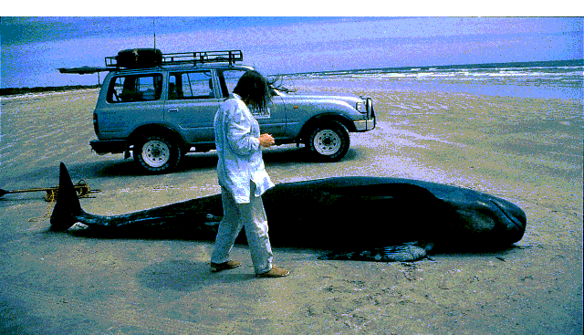
Jennifer Thurmer, South Australian Museum, checking out a dead long-finned pilot whale which stranded alive along the Coorong in late 1994. Fisheries officers helped the Museum to collect the 1020 kg, old female.
Mangroves are one of our most important and widespread coastal wetlands. Together with seagrasses and tidal saltmarshes, these coastal wetlands are of enormous ecological, economical and social significance.
In Australia, mangrove forests occupy approximately 11,600 sq km of coastal foreshore and estuary areas. These forests and estuaries are vital to the biological productivity of Australia's coastal waters. In Australia, nearly 80% of fisheries are based on estuaries. In recent years mangrove environments all around the world have come under increasing pressure from coastal development. Fortunately, Australia is one of the few countries with large areas of mangrove forests which have not yet been overexploited.
Mangroves tend to dominate the tropical and subtropical coastlines of Australia, both in area and in number of species. While over 95% of mangrove forests lie in tropical Australia, South Australia is fortunate in possessing some of the largest areas of temperate mangroves in Australia.
Mangrove trees are true flowering plants that live on the edge of the coast in the narrow zone between the land and the sea known as the intertidal zone. Mangroves is a term given to either a single species of mangrove tree, a collection of different species of mangroves, or an entire ecosystem where mangroves are found.
In South Australia, the mangrove forests are composed solely of the grey mangrove. In S.A. this plant grows to about 3.5 to 5 metres high and is easily recognised by its light green leaves with a silvery-grey undersurface and pencil-shaped aerial roots called pneumatophores which project vertically from the sediment surface. The pneumatophores grow vertically upwards from the network of shallow, radiating horizontal roots, sometimes called cable roots.
Let's stop and consider the environmental conditions that the mangrove tree has to endure. It's not that often that you see trees growing submerged in water, let alone salt water. For this reason, mangrove trees have developed special features to survive in this environment.
The intertidal mangrove environment is influenced by both land and sea processes. Consequently, plants and animals which live in the mangrove forest have to withstand or adapt to both worlds and also to the constant changes in the environment.
To survive in this harsh and variable environment, mangroves have developed special anatomical and physiological features. The grey mangrove has developed a high tolerance to salt. It is capable to actively eliminate up to 95% of the salinity of seawater through special tissues in the lower stem and roots. Any remaining salt is eliminated through special glands on the underside of the leaves.
Why are mangroves so important? In S.A. mangroves:
Falling between both worlds, land and sea, the animals of the mangrove forest belong to both worlds. Birds, mammals, reptiles and insects enter the forest from the land, while the high tide brings fish through he submerged portions of the mangroves (forest) feasting on crustaceans, worms and molluscs which inhabit the forest floor.
Mangrove areas, and their associated
seagrass and saltmarsh habitats, are important nursery and feeding
areas for many fish and crustacean species in S.A.. However, their
coastal location means they are often under threat from coastal
developments and the effects of pollutants from nearby urban centres,
and also from direct human impact.
Coastal Development
In many parts of Australia, mangroves
and saltmarshes are being cleared at an unprecedented rate to
make way for marina developments and harbourside tourist and recreational
areas.
Land-based Pollution
Pollution threats to our coastal
mangroves-seagrass habitats comes from several sources including
industrial discharges, sewage and sludge effluent outfalls and
also, the cumulative pollution, or runoff, from a number of industrial,
urban, or agricultural sources.
Oil Spills
Coastal wetlands, particularly
mangroves, are both vulnerable and sensitive to oil spills.
Litter and People
Unfortunately, mangroves are not only a favourite place for fishing, but they are also popular for the dumping of rubbish. Another threat to mangroves is the very presence of people themselves. Small mangrove seedlings, and the delicate pneumatophores of mangroves are likely to be damaged by foot traffic.
In addition to setting aside specific areas for protection, it is imperative that we understand that the degradation of our coastal environment often occurs slowly and insidiously, and moreover, is often a direct result of our human activities. To this end, community education is a fundamental tool in not only raising the awareness of the nature and significance of our mangroves and coastal wetlands in South Australia, but also, in identifying the major threats to these valuable ecosystems.
I believe that people who have
an interest in marine studies, would be interested in reading
what a student in senior schooling understands about mangrove
forests.
Bibliography

The Dragon Search seadragon community-monitoring
project now has part time coordinators in each state where seadragons
are known to occur. To improve coordination of the Project nationally,
the Marine and Coastal Community Network and Threatened Species
Network SA recently held a national meeting in Adelaide to work
through national organisational structures, review data collection
procedures and data management and review the text for new national
survey forms and brochures. The project is supported between the
states through a small but diverse mix of Coastcare and Fisheries
Action Program grants as well as direct support from Western Australian
Fisheries, the MCCN, TSN (SA) and the Australian Marine Conservation
Society. Almost twenty organisations are directly involved in
project support around the country.
Queensland and Northern Territory
groups are interested to investigate extension of the project
into other areas of syngnathid conservation outside the range
of seadragons. The project could readily be adapted for the main
species of seahorses found in our waters. However tackling the
identification of Australia's thirty or more pipefish presents
problems for field identification.
Marine ecologist Janine Baker
has recently completed another analysis of the South Australian
data. There is a need to wait until the other states programs
generate more records before a national analysis is worthwhile.
Brooding records are still coming in for this season. The latest
querying of data has only just been completed and there has been
little time to examine results in detail for this article. However
some crude observations on some of the basic queries are offered.
It must be realised that there
are limitations of the project with regards to determining status
or population estimates. What the data is able to give are species
distributions, and information on habitat and physical characteristics.
Information on breeding times around the coast is also coming
in. Brief summaries of some of the queries run on the database
are given here, but there is a real need for more data and correlation
with national trends.
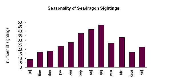
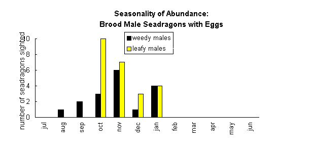
From the records to date there
are some seasonal trends with regards to breeding. Weedies appear
to have a more protracted season and start as early as August,
through to January with a peak in November. Leafies appear to
be restricted to October through to January, with a peak in October.
There are no records for either species past January.
The sightings of juveniles appear
quite spread out between October to May. There may be some difficulty
with divers classifying juveniles. One may infer that either divers
are seeing fish from that season's years or year old juveniles.
For both species there is a peak
in beach washed animals between September to January. Males with
eggs have been washed ashore around this time. Whether there is
any correlation with stress related to breeding, or brooding animals
moving closer in shore and thus being more susceptible to storm
events will need more examination of national trends.
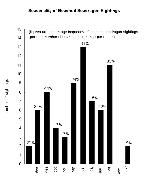
The depth at which both seadragons
are seen ranges from one metre to 17 metres for Leafies to 22
for Weedies. Most Leafy sightings occur between the 3 and 5 meter
mark while Weedies appear to be seen more frequently at depths
between 8 to 12 with other peaks at 4 and 20 metres.
From data to hand, both Weedies
and Leafies appear to have a tolerance for a range of water temperatures
between 12°C and 23°C. However slightly more leafy records
occur e between 16 at 18°C, and Weedies at 16°C. One
query worth investigating at a national level is correlation to
water temperature and brooding male sightings.
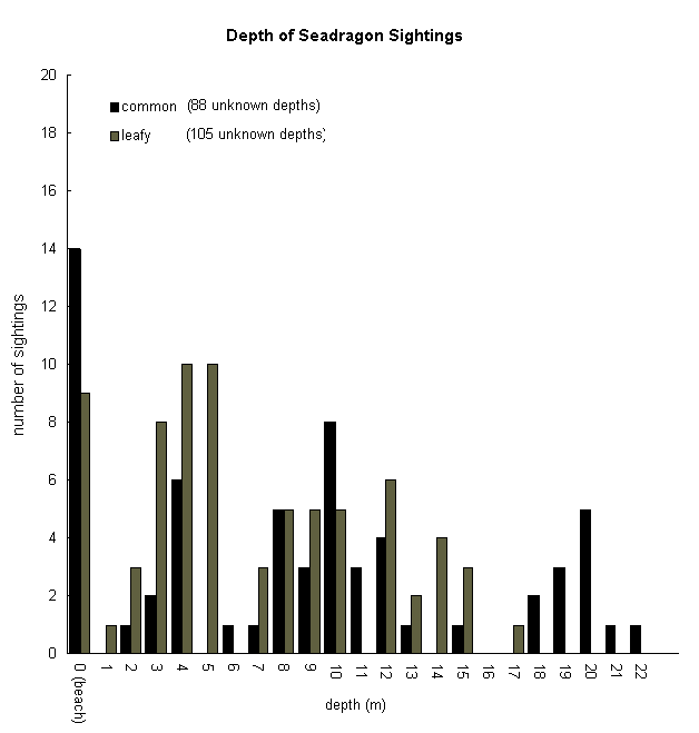
| ||||
| beached | ||||
| seagrass and macroalgae | ||||
| seagrass | ||||
| macroalgae | ||||
| bare subtidal sand | ||||
| reef (invertebrate dominated) | ||||
| other | ||||
| unknown |
| ||||
| beached | ||||
| seagrass and macroalgae | ||||
| seagrass | ||||
| macroalgae | ||||
| bare subtidal sand | ||||
| reef (invertebrate dominated) | ||||
| other | ||||
| unknown |
The reports also give some insight
into mortalities and some threatening processes. One surprise
was the number of foul-hookings of leafy seadragons by recreational
fishermen at a well-known jetty dive site. By-catch in prawn trawl
fisheries and the previously poorly regulated removal by aquarium
collectors are other threats.
By far the greatest frequencies
of sightings come from Gulf Saint Vincent, followed by Eyre Peninsula,
which may well be related to popularity of dive sites than true
abundance. Seadragons are seen throughout the year, but the key
viewing months appear to be October through to April, and in particular
December, January, February and April.
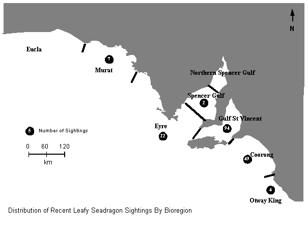

The Dragon Search database is
community generated information, and as such should be available
to the community in some form. However, in the initial stage concerns
were expressed by a number of divers not to provide information
on specific locations, which may be used, for legal and illegal
collection of these fish. Reports generated for general use tend
to incorporate information at a regional level rather than site
specific information. I have in this update included a brief regional
map showing distribution of more recent sightings. It should be
understood that the more popular dive sights to see seadragons
are pretty well know by the diving fraternity.
As one of the few fish species
on the Fisheries Protected species listing, some community groups
have asked Dragon Search to use the presence of Leafy seadragons
in an area as a means to limit damaging developments in the marine
environment. However there still is not enough information to
give a clear idea of status and potential impacts to the species,
although habitat destruction and modification are certainly threatening
processes. Whilst both Weedy and Leafy Seadragons were listed
in the International Union for the Conservation of Nature 1996
Red List of Threatened Species the rationale for the listing is
with regards to lack of data rather than knowledge of the real
status of these fish.
However there is good reason for
caution and the recent policy developments at both Federal and
in other states are reassuring.
What the project is showing is
that seadragons and seahorses are an extremely popular species
that captivate the public imagination. Seadragons can be a "flagship
species" for marine conservation in southern waters. As such
they can serve as a rallying point for major conservation initiatives.
Fish such as the seadragon highlight
the high degree of uniqueness or endemism of species that exists
in southern temperate waters. For example, as well as the many
unique fish and invertebrates, there are twice as many species
of seaweeds alone in southern waters than on the Great Barrier
Reef and off Ningaloo Reef in W.A. Australians are not generally
aware of the immense marine biodiversity they have off their southern
coast and the spectacular and unique environments that exist there.
Awareness generated by the Dragon
Search project has been beneficial in generating interest in other
marine monitoring projects such as Reefwatch, a community reef
monitoring program being developed by the Conservation Council
of South Australia.
There is also potential for local
"eco-tourism" industry to develop, based on dive and
snorkel tours to view seadragons. This could act as an additional
eco-tourism focus out side of the whale-watching season in communities
such as Victor Harbor in South Australia. There has been local
interest in such a proposal, however information on the occurrence
and abundance of the species at these areas is necessary to determine
the feasibility and seasonality of such an industry and also the
possible impacts that could be associated with it. The Dragon
Search monitoring program hopes to assist in determining such
guidelines, and provide data needed in the development of a "Diving
with Dragons" program, as well as promoting stewardship of
local populations of these fish to prevent poaching and other
impacts.
Most people are familiar with
the "charismatic marine mega-vertebrates", marine mammals
such as whales, dolphins or sea lions. In Southern Australia marine
protected areas for vulnerable species have been established for
sea lions and more recently habitat protection for Southern Right
Whales. There are however a number of fish and invertebrate species
and their habitats that may be vulnerable, but there is little
information available to assess their status or define areas for
habitat protection.
The Dragon Search project appears
to be successful in creating awareness of potential impacts to
seahorses, pipefish and seadragons and more importantly, the marine
environment. The data is helping to define important habitat areas
for Seadragons and may assist in the establishment of marine protected
areas in significant habitat areas.
As with last year's Journal report, there have been more additions to the number of slides in our photographic index of South Australian marine life.
At the time of writing, there are now 140 fish slides in the Index. Seventeen fish slides have been added since the last report, although eleven of these fish were already featured in the Index. The newer slides were chosen as being of better quality.
As indicated last year, the Index now includes marine invertebrates. There are 46 invertebrate slides with species from seven phyla.
All but two of the new additions to the Index are the work of David Muirhead to whom we remain indebted.
The update list in last year's
Journal contained a few errors. Slide No. 10 is the same species
as slide Numbers 99 and 116. Slide 115 had its Genus and Species
names transposed on the list. Its full scientific name is Eubalichthys
mosaicus.
Slide 86 has now been confirmed to be that of a Barber Perch.
David Muirhead is now certain that slides 94 and 95 are Mosaic Leatherjackets, not Gunn's.
Slide 96 is a Yellow-striped Leatherjacket, not a Yellow Leatherjacket.
Slide 98 is a Spiny-tailed Leatherjacket,
not a Spiny-tail.
Most of the slides in the Index
are now able to be seen as a part of our web page on the Internet.
Ways to improve the Index as an educational site on the Internet
are still in the planning stages.
| To Home Page |