Marine Life Society of
South Australia Inc.
Newsletter
February 2006 No. 329
“understanding,
enjoying & caring for our oceans”
Next Meeting
This will be the February General Meeting and will be held at the Conservation
Centre, 120 Wakefield Street, Adelaide on Wednesday 15th
February commencing at 7.30pm.
Our speaker will be Robyn Morcom who will be speaking on
the new Dolphin Sanctuary.
CONTENTS
Some Of SA’s Long Lost Jetties - Part 1 (Steve Reynolds)
Newsletter Articles
We only have one article this month
and this is from Steve Reynolds. He is the only one to have taken the time to
produce one. I prefer to provide members with a variety of articles from
several sources but as nobody else has taken the opportunity to provide articles then Steve
has become the main contributor. I am very grateful to you Steve.
Please put pen to paper or finger to keyboard and
help to provide a selection of topics for YOUR NEWSLETTER.
Philip
Some Of
SA’s Long Lost Jetties (Part 1)
SA’s First Jetty
Picture credits: (SR) = Steve Reynolds (NR) = Noeleen Reynolds
The
colony of South Australia was started by the South Australian Company which had
been established by an Act of Parliament in England. Its charter was to
establish a colony somewhere between the Great Australian Bight and Port Philip
Bay. It chose to start at Kangaroo Island. The barque Duke of York
anchored in Nepean Bay, Kangaroo Island on 27th July 1836 and its
passengers began SA’s first formal settlement at a spot known to sealers and
whalers. It is a promontory of land dividing the Bay of Shoals from Nepean Bay
proper. It was originally known as Snake Point and went through several name
changes. It next became known as Reeves Point after a settler called Augustus
Reeves. It then became known as Kingscote Point and Beatrice Point. Kangaroo
Island’s first jetties were built at Reeves Point.
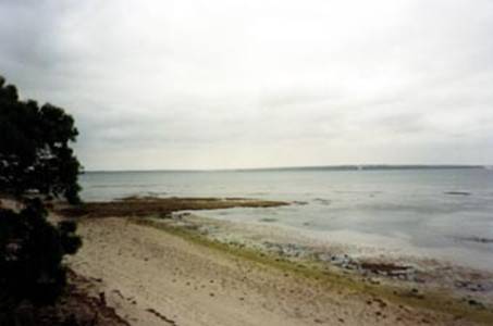
Photo 1: The site of the first ‘jetty’ (ironstone
landing) built at Reeves Point (SR)
Several attempts
had to be made to build a jetty there due to a lack of suitable building
materials. The first attempt to build a jetty there resulted in a rough
ironstone landing built in late 1836. There is a sign explaining this at the
site. I visited Reeves Point in August 2004 and went to see the site of the
first ‘jetty’ (and the sign). Pardon the pun, but from the beach I couldn’t see
any sign of the old ‘jetty’.
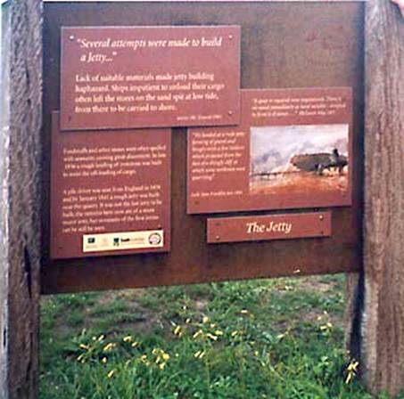
Photo 2: The sign about the first ‘jetty’ at
Reeves Point (NR)
The sign about the first jetty (ironstone
landing) featured a painting by EC Frome of a jetty
in the area in 1840. The painting is also featured in the “Reeves Point
Historic Site” pamphlet courtesy of the Art Gallery of SA where it can
apparently be seen.
The first real
jetty was built at Reeves Point in 1838 and the stumps of a few small piles can
be seen on the beach at low tide. In his
book titled “The Jetties of South Australia – Past and Present”, Neville
Collins says that a second jetty was erected at the outlet of a gully about
300m south of the first.
The Old Quarry Jetty At Reeves Point
In
January 1841 a pile driver sent out from England was used to build a rough
wooden jetty below a basalt quarry at Reeves Point. According
to the pamphlet “Reeves Point Historic Site”, the basalt from the “quarry was
first used as ballast for ships. From 1840-1841 it provided basalt for
road building on the mainland”.
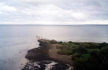
Photo 3: View of the quarry jetty from close to
the quarry (SR)
Basalt is a dark
green or brown igneous rock, often in columnar strata. Basalt from the Reeves
Point quarry jetty was used to construct Old Port Road from Port Adelaide to
Adelaide.
Neville Collins says that the quarry jetty was probably built after 1850.
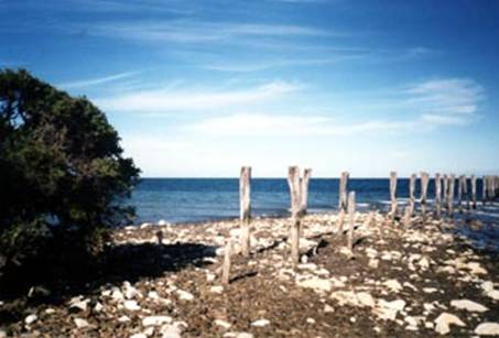
Photo 4:
Close-up of the old quarry jetty at Reeves Point (SR)
Stone Pier At Marino
In “The Jetties
of South Australia – Past and Present”, Neville Collins says that a stone pier
was built at Marino about 1840. He says that a ridge of stones extending out to
a marker buoy is still visible today at low tide.
The Old Port Willunga Jetty
The
first jetty at Port Willunga on the Fleurieu Peninsula was built in 1853. This
jetty needed to be lengthened. It was made 145m long by July 1857 but the water
at its end was still too shallow. A new jetty had to be built nearby (400m
south). This new jetty was built between 1867 and January 1868. The jetty was
apparently 186m long and 5m wide and there were double tram tracks onto the
jetty. In his “Issues” column in the Advertiser of 1st August 2000,
Rex Jory wrote that what was left of the old jetty had been “destroyed when
authorities feared it could be used as an invasion point during war” (during
World War II). He also wrote that one could “see the curved line of the old . .
. jetty. Worn pylon* stubs, snapped off at ground level, are jutting from the
sand, some joined by thick timber planks preserved by lying beneath the
surface, protected from the battering sea”.
Neville Collins says in “The Jetties of South
Australia”, that the “Stumps of the first jetty were uncovered after a storm in
1982”.
* When it comes
to jetty terminology, I prefer the word ‘piles’ to ‘pylons’. My dictionary
tells me that a ‘pylon’ is a tower-like structure whereas a ‘pile’ is a “piece
of heavy timber or concrete driven vertically into the ground as support for a
structure”. A Mr Bill Sloan had a similar view in 1999 when he wrote in to The
Advertiser. He finished his letter to the Editor with the comments “Down with
piles and up with pylons”.
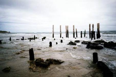
Photo 6: Remains of second Port Willunga jetty
(SR)
The Old Port Broughton Jetty
The
town of Port Broughton was surveyed in October 1871. Captain Henry David Dale
named the town after Bishop William Grant Broughton, the first Anglican
Bishop of Australia. The first allotments in the town were offered for sale in
March 1872.
There are two jetties at Port Broughton, the old
jetty and the new one. Captain Dale built the old one in that first year
(1872). It was a small jetty (or landing) and it remains can still be seen
there today. A second jetty 384m long was then built on the site of the present
day new jetty between 1873 and 1874*. This jetty was, however, in such poor
condition by 1876 that it had to be replaced. The present jetty was completed
in 1878.
Neville Collins says that another small jetty was
built on the site of the present boat ramp at Port Broughton in 1910 to serve
the Australian Marine Fibre Works.
*Many dates and lengths are
quoted throughout this article. These dates and figures may be contradicted in
other writings. It is not unusual to come across varying details. Wherever
possible, I have tried to use the details in “The Jetties of South Australia –
Past and Present” by Neville Collins.
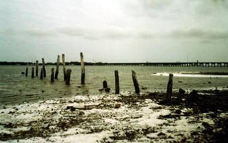
Photo 7: The remains of Capt. Dale’s small jetty
at Port Broughton with the new jetty in the background (SR)
The Old Port Minlacowie Jetty
A 350m-long jetty was built at Port Minlacowie on the
Yorke Peninsula in 1877. It was Government owned and controlled by the Minlaton
District Council. According to the Southern Yorke Peninsula visitor’s guide of
December 1993 “The long jetty served the ‘mosquito fleet’ of ketches which came
to take the district’s bagged grain to Port Adelaide for onward shipment.” The
guide also said that the jetty had “distinctive davits (which) provided
security for the boats . . (of
fishermen)”. A cairn on the shore there (unveiled on 2nd March 1986
for SA’s 150 Jubilee), says that the remains of the jetty were destroyed by the
State Government in 1971. The 1993 SYP visitor’s guide says that the cairn
“commemorates the port’s place in the grain industry of bygone years”. A 1990
RAA book says that “What was left of the jetty was used a few years ago to
repair the one at Port Rickaby”.
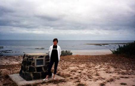
Photo 8: Noeleen Reynolds at the Port Minlacowie
cairn (SR)
The book “Yorke
Peninsula . . . A Resident’s Views” by Allan Parsons features several photos of
Port Minlacowie including one of the weighbridge there in 1947 and three of the
jetty there. In April 1988 some twelve MLSSA divers explored the site of the
old jetty. It was the Easter holiday long weekend when we dived at the site.
Stumps of the jetty were easily seen during the dive and the outer end of the
jetty was easily found.
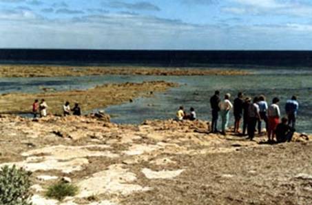
Photo 9: Society members surveying the site of the
old Port Minlacowie jetty in 1988 (SR)
The Old Port Moorowie Jetty
Rodney Cockburn’s book “South Australia – What’s in a
Name? (Historically significant place names)” says that ‘Moorowie’ “is native
for ‘sand water’ ” and “The township at Port Moorowie was sold in June 1878”.
In
“A Cruising Guide to Historic Gulf Ports – Vol.2”, Graham Scarce says that
“White settlers moved into the area in 1878 when the first farming lots and
town sites were sold”.
In the same book
Graham Scarce also says that, when the first settlers tried to transport the
first yield from their crops to market “a major obstacle was highlighted which
led to the community pressuring the Government to build a jetty at McLeod
Harbour”.
An 87m-long jetty controlled by the Marine Board was built at Port Moorowie
in 1881.
The site was
once considered to be the best one for a deep-sea port rather than Giles Point
but this was probably decided against because it is subject to southerly gales.
It had always been a “nightmare” port due to exposure to the rough seas of the
Southern Ocean. Storms damaged the jetty in 1915 and 1953. It was then
demolished and removed as it had become unsafe.
A Doug Hart won
the tender to demolish the jetty in 1955. He was still demolishing the jetty
when he accidentally set it on fire in 1956. There were two sets of piles to
each section of the jetty and the fire burnt three of these. Details of the dismantling
and the resulting fire can be viewed on the Port Moorowie web site at http://www.netyp.com/member/moorowie/history
5.htm . A storm put the fire out and messed up the jetty but Doug cleaned up
the mess.
The
following two photographs of the jetty are taken from the Friends of Port
Moorowie web site which is linked to the MLSSA web site.
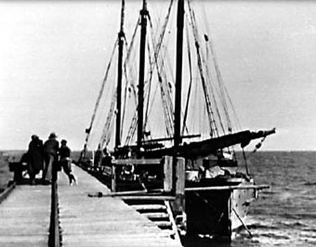
Photo 10: Ships moored at the Port Moorowie jetty (From the Friends
of Port Moorowie web site, reproduced courtesy of the Yorketown History
Society)
There were
once grain stacks on the shore at the jetty. These were made of vertical wooden
slats. They sat on a 400mm high brick and plaster base. The sides of the stacks
were covered in hessian whenever the stacks held grain. When it became
unprofitable to cart grain to Port Moorowie, the grain stacks were removed. The
base of the stacks, however, can still be seen.
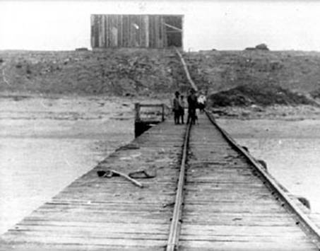
Photo 11: View of the grain stacks from the Port Moorowie jetty
(From the Friends of Port Moorowie web site, reproduced courtesy of the
Yorketown History Society)
Doug Hart had a farm at Edithburgh at the
time of his tender work. His son Graeme now runs that farm which is where a few
remnants of the old jetty can still be seen.
In October 1988 I went down to the Port Moorowie
boat ramp on the Yorke Peninsula. A few jetty pile stumps could be seen
protruding from the water during a rising tide. I went scuba diving to try and
follow the piles out to the outer end of the jetty. I continued to find one
pile after another. Some of the pile stumps stood one metre high and some were
fairly wide. Towards the end of the trail I found old chains, bolts and mooring
rings.
To be continued