Marine Life Society of South Australia Inc.
Newsletter
January 2005
No. 317"understanding, enjoying & caring for our oceans"
Next Meeting
Our meeting will be held at the Conservation Centre, 120 Wakefield Street, Adelaide on Wednesday 19th January commencing at 7.30pm.
Our speaker/s will be Chris Hall and David Muirhead with a selection of new slides from recent dives.
Contents
Thank You Tim Hoile and the Star of the Sea Marine Discovery Centre (Philip Hall)
The Wreck Of The Kona (Steve Reynolds)
Dredging of Eight Mile Creek (Part 1) (Neville Skinner)
Editorial
I hope everyone had a merry Christmas and you have made a splendid start to the New Year and are keeping all of your resolutions!!!
The hard copy of the 2004 Journal was sent out in December and I hope everyone enjoyed the selection of articles in it. If you are not on our mailing list then the online copy is available by clicking on the "Journal" tab to the left of the front page of this website.
Thank You Tim Hoile and the Star of the Sea Marine Discovery Centre
by
Philip HallDuring a lunchtime discussion at the Star of the Sea Marine Discovery Centre in November 2004 Margaret and I realised we had been associated with the Centre as volunteers for four years. During this time we have had many enjoyable experiences and met a very large number of interesting and influential people.
Tim is to be congratulated for his steady development of a Centre dedicated to educating the community about the marine environment in an interesting and informative way. The new development plans, when they come to fruition, will allow the Centre to stay the pre-eminent marine learning Centre in this state.
Each week we have met and talked with children from many different schools and kindergartens from all over the state. We have also shown adult groups and foreign students around the Centre. We have also had the pleasure of interacting with many of the teachers and adult helpers who accompany these groups.
MLSSA has benefited in many ways from our working at the Centre. Tim sells our calendars and helps to publicise us in many and varied ways. He has used pictures from our Photo Index to illustrate some of the community projects the Marine Centre has been involved in and to also publicise our Society. Our comments and expertise is sometimes considered in the formation of some of the projects undertaken by the Centre.
During the year Tim holds many events when helpers, volunteers and/or sponsors can meet to socialise and network. We have been able to use some of these occasions to enlist speakers for MLSSA meetings, to get articles for Journals and to make a variety of helpful contacts.
Through working at the Centre as volunteers we have thus been able to assist both the Centre and MLSSA in many ways.
All of this would not have been possible without the guidance and foresight of the Director Tim Hoile and assistance by Ursula Quack-Weatherly, his very able office assistant, in the running of this wonderful learning Centre.
by Steve Reynolds
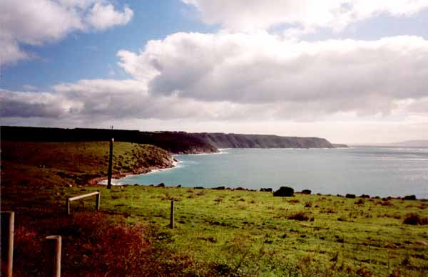
Articles by myself in 1988 & 1997 both mentioned the wrecks of the Sir Wilfred Lawson and the Kona around Port Moorowie. Another article of mine in our May 1999 Newsletter (No.255) discussed these two wrecks in detail. There was, however, a question about the location of the wreck of the wooden schooner the Kona. Some old maps that I had gave the shipwreck’s location as Mozzie Flats, near Port Moorowie but other references that I found gave the location as Scraper Shoal in Backstairs Passage. I recently visited Cape Willoughby at Kangaroo Island where I found out a little more about the Kona. She was wrecked in 1917 at Scraper Shoal near Cape St Albans on Kangaroo Island. Some sources say that it occurred on either 3rd January or 3rd February 1917. I have also seen the year given as 1916.
Cape St Albans viewed from Cape Willoughby
(Photo by Noeleen Reynolds
)Cape St Albans is in Backstairs Passage near Cape Willoughby. It separates Red House Bay from Moncrieff Bay. These two bays are east of Antechamber Bay.
According to "A Cruising Guide to Historic Gulf Ports – Vol.2" by Graham Scarce, "Cape St Albans is a prominent tongue of land that extends in a north-westerly direction from the eastern end of the Dudley Peninsula. At the extreme end of the cape the terrain rises very steeply to 39m from the turbulent waters. It then continues to rise slowly along a ridge to 90m a further half-mile inland. At this point is the Cape St Albans Lighthouse".
Scarce’s book also says that "Cape St Albans was named by Capt. Thomas Lipson, RN, SA’s first Habourmaster, who named the cape in March 1850 after St Albans in Hertfordshire, England".
According to the web page
http://www.environment.sa.gov.au/parks/cape_willoughby/ship.html#kona
"The Kona was a 4-masted American schooner built at Alamedo, California in 1901. The vessel was 55.81m long, 11.53m beam and 4.25m deep. On 3rd of February 1917*, 73 days after leaving San Francisco, a record low tide forced the Kona to strike the Scraper Shoal. The Kona was travelling at 18 knots, the impact threw a life raft into the air - it was smashed to pieces. At 1.15 pm the crew abandoned ship."
*Sources such as "A Cruising Guide to Historic Gulf Ports – Vol.2" by Graham Scarce suggest that the date should be 3rd January.
Scarce’s book says that the Kona was slightly longer (56.6m) and of 679 ton. He also says that the schooner "was threatened by a south-east gale on January 3, 1917" whilst she was "off the south coast of Kangaroo Island. The Captain elected to pass between Yatala Shoal and Kangaroo Island to reach the shelter of Eastern Cove. Running before the wind and registering 18 knots under full sail, the Kona ploughed onto the Scraper. Huge seas immediately began breaking over the vessel and both lifeboats were smashed, however one was temporarily repaired with canvas, and the crew abandoned ship as the Kona broke up under their feet. There was nothing left within 30 minutes of striking the shoal, except wreckage which was dispersed as far away as Cape Spencer where the aft cabin washed ashore".
The reason for the confusion over the wreck site of the Kona is the fact that, according to Scarce, her wreckage was distributed over a large area. Her bow later turned up at Mozzie Flats, near Port Moorowie. This, it seems, led to Port Moorowie (and the whole of the Yorke Peninsula) claiming the wreck as their own. "Yorke Peninsula . . . .A Resident’s Views" by Allan Parsons lists the Kona as one of the shipwrecks around the coast of Yorke Peninsula, saying that she was "wrecked (at) Port Moorowie".
According to Scarce though, the truth is apparently that "The foreward (sic) section (of the Kona) was found drifting in Investigator Strait and towed to Sandy Point at Point Davenport and beached. This and other pieces of the wreck* were used to construct the "Kona Hut", a weekend residence on the shores of Foul Bay".
*The ‘other pieces of the wreck’ must be the aft cabin which, as already mentioned above, Scarce says washed ashore at Cape Spencer.
Cape Spencer is located at the southern-most point of Yorke Peninsula. Sandy Point at Point Davenport is about 9nm SW of Port Moorowie. Port Moorowie itself is on the shore of McLeod Harbour in Waterloo Bay.
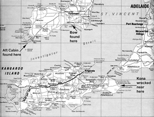
Map annotated by Philip Hall
Dredging of Eight Mile Creek (Part 1)
Author: N. R. Skinner, October 2004
Intro:
I first snorkelled Eight Mile Creek on 13th July 2003 with dive buddy Daniel Habib. It was raining heavily at the time but we were there to enjoy the experience and this did not bother us. We had both heard how stunning Eight Mile Creek was, all the way to the sea. We parked one car at the mouth for the return journey, and then headed off to Ewens Ponds for the start of the experience.
The following article describes what we saw on that dive, and what we have subsequently found in pursuit of the facts. You will find this an enlightening and possibly disturbing article…
Eight Mile Creek was so named because it is located eight miles to the east of Port MacDonnell. It serves as the interconnection from Ewens Ponds to the sea, approx 4.4 kilometres in length from the start of Eight Mile Creek, although most divers would only be aware of the 3.5 kilometres from the first pond to the sea. As such it is a critical part of the greater Ewens Ponds system, carrying something in the order of 150 mega-litres of water to the sea each day from the Ponds (or if you prefer, 57 Giga litres per year or 1.8 m3 per second).
Ewens Ponds consists of several freshwater ponds in series, formed by water pushing up out of the ground in a series of springs that actually continue past the Ponds and down Eight Mile Creek itself. The Ponds are fairly large in size, each extending to a depth of about 9-12m, and spread over a distance of around 300-400m, interconnected by narrow channels.
At one stage the third Pond contained a cave; today only the remnants of this remain, as I believe it was virtually destroyed through the use of explosives used for the fishing of native freshwater Shortfinned Eels some 30-40 years ago.
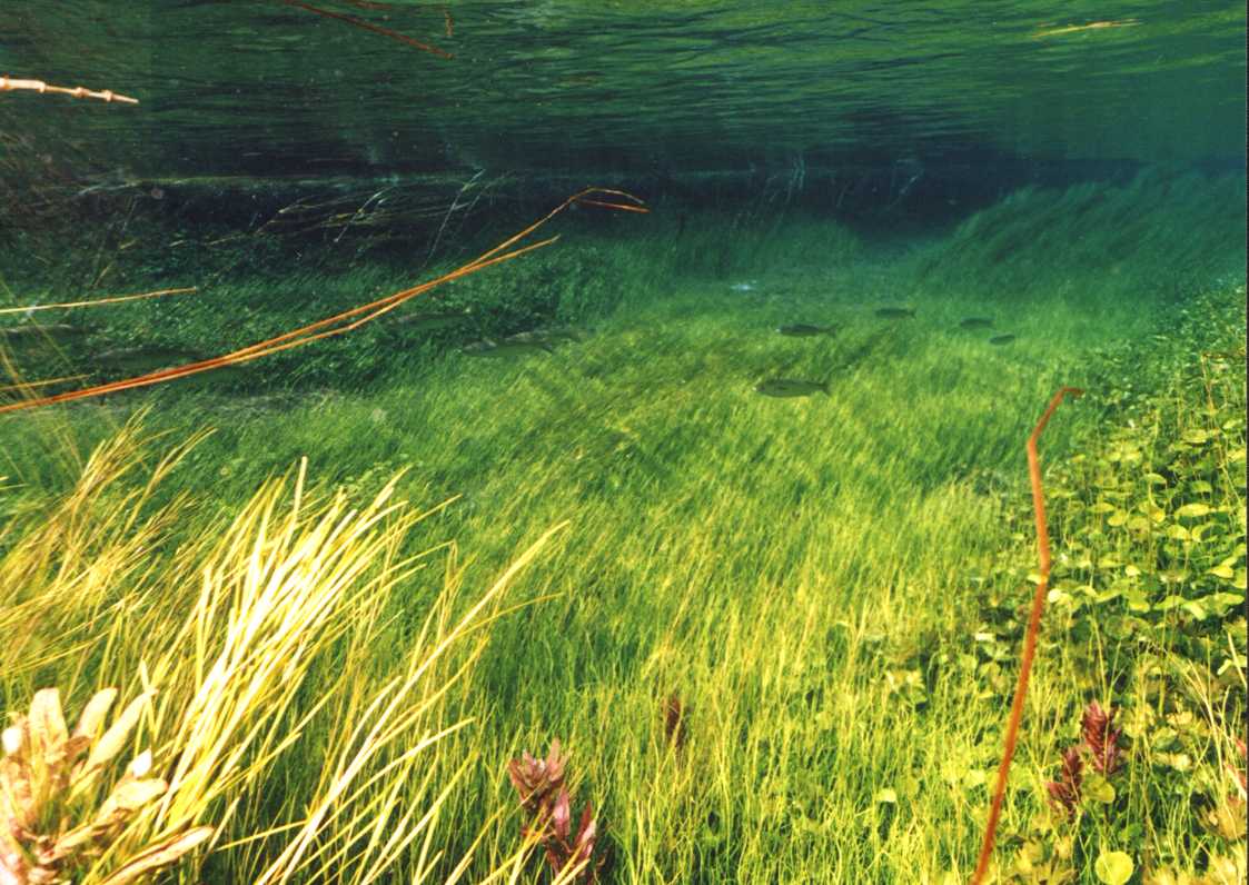
The Ponds, their interconnecting channels, and Eight Mile Creek provide an excellent location for snorkellers and divers alike, who visit the area all year round to admire the exquisite beauty of the site. This beauty is provided by stunning native aquatic vegetation of various shades of greens and yellows, intermingling with the blues of the water, the browns and whites of the mud and limestone bottom, and the natural sunlight.
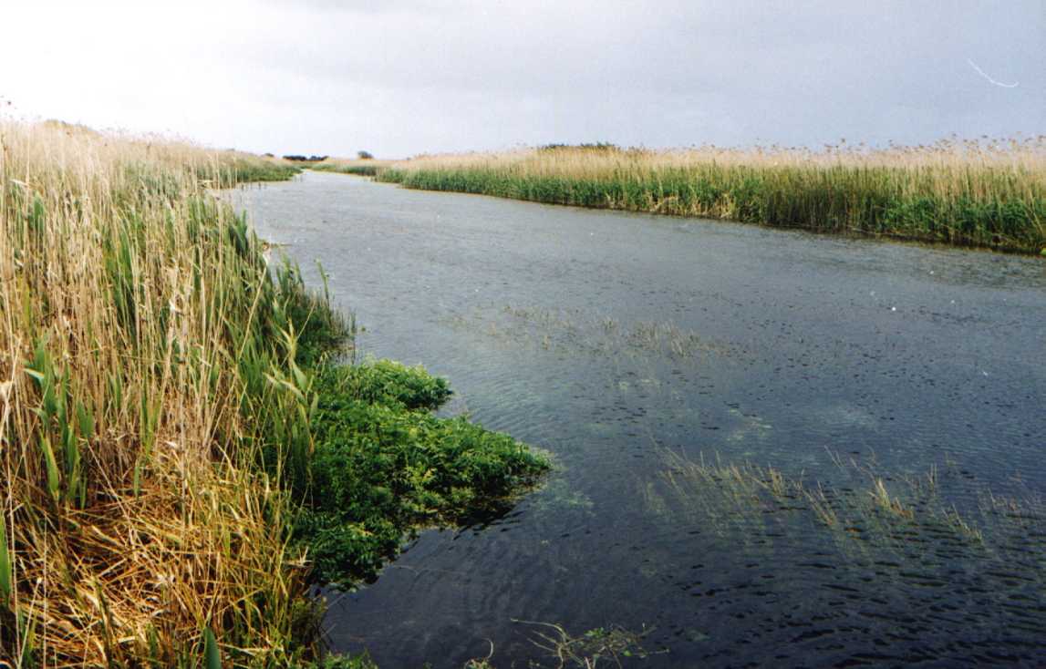
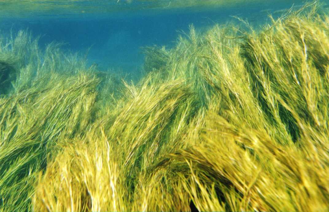
Eight Mile Creek before dredging – above and below the surface
(N.Skinner)
Visibility seems to reach infinity, as one can see as far as possible in the crystal clear waters containing various species of fish including the protected Southern Pygmy Perch, and the protected (and threatened) Ewens Pygmy Perch that feed on small shrimps and other invertebrates. The Southern Pygmy Perch can be found amongst the vegetation that grows in the creek, as they are not strong swimmers, while the Ewens Pygmy Perch has a unique preference for strongly flowing water. The Ewens Pygmy Perch is only found in a very small area of the lower South East of SA, and in the Glenelg River system.
Imagine our surprise in July last year, whilst snorkelling from Ewens Ponds down Eight Mile Creek to the sea in heavy rain, to discover at a point about one-third to one-half of the way down, that the stunning beauty of the creek had suddenly and dramatically turned to silty water, green from the algae contained within it (photos available).
We were both shocked to have swum into a complete white silt-out laden with green algae.
How could this be?
After some investigation, involving e-mails to the Dept of Environment, the EPA and the SA Minister (for the Environment) John Hill, who was very helpful in seeking answers on this issue from his department(s), I learnt this was the result of "maintenance activities" conducted by the SE Water Conservation and Drainage Board.
I learnt that during these "maintenance activities" a dredge is pulled up and down the creek for two days until it is free of native aquatic vegetation. The purpose of this is to decrease the resistance to water flow, leading to a significant decrease in water level, and thus better drainage for the dairy farms adjacent to that area.
This occurs once or twice a year, usually following telephone calls from dairy farmers who complain their paddocks are not draining effectively, as the water level starts to rise.
Sometime after the war the area was set aside as land for use by ‘Soldier Settlers’, and drains were created that ran into Eight Mile Creek, as well as directly to the sea, in order to lower the water table so that the surrounding wetlands could be converted to dairy farmland. In fact most of the surrounding area consists of peat, and I recently observed that the area I was standing on moved up and down as someone near me jumped up and down on the spot!
Around 1956, the lower section of Eight Mile Creek was widened to further improve the drainage, through the use of large D4 Caterpillar tractors.
(I suspect the parallel lines one can see today on parts of the creek bedrock are from the blades of those Caterpillar tractors 45 years ago.)
In order to maintain the drainage system our predecessors started the practice of the annual dredging of Eight Mile Creek, from the Ponds to the sea, as the removal of the aquatic vegetation allowed the water to flow significantly faster. This results in a drop in the water level, which in turn more effectively drains the surrounding land.
Today the dairy farms still exist, and so do the drains. A plaque at the entrance to Ewens Ponds marks the original water level of the area, which is approx two metres above today’s level.
To my surprise I discovered few people were even aware this had been happening; in fact I learnt that up until about 2001 the creek was dredged all the way from the sea to the Ewens Ponds Conservation Park boundary.
Listed1 amongst the fish that are known to inhabit Eight Mile Creek are Common Galaxias, Spotted Galaxias (vulnerable), Southern Pygmy Perch (protected and rare in SA), Variegated (Ewens) Pygmy Perch (protected and endangered in SA), Congolli (rare in SA), River Blackfish (protected and endangered in SA), Shortfinned Eel (rare in SA), Smallmouthed Hardyhead, Australian Grayling (critically endangered in SA), Pouched Lamprey (endangered in SA), Shorthead Lamprey (endangered in SA), and the native freshwater Spiny Crayfish.
Eight Mile Creek where it departs Ewens Ponds (N.Skinner)
For those not familiar with the various levels of species endangerment, in order they go something like this (brackets indicate sub-categories) - Uncommon, Rare, Poorly Known, Threatened (Vulnerable, Endangered, Critically Endangered), Extinct (Extinct in the Wild, really Extinct).
(‘Protected’ is different – it just means the Government has seen fit to pass legislation to protect it.)
A comprehensive report2 in 2002, into the health of the South Australian Marine Environment, described Eight Mile Creek as "the only significant river in the whole region".
It went on to state: "All of the South Australian fish species which are officially designated as ‘Rare’, ‘Vulnerable’, ‘Endangered’ are freshwater species. Since 1988 an additional 15 species have been recorded for the State and a further 3 species have been rated as extinct (DELM 1993)."2
And in another section it says:
"There is an urgent need for a state-wide wetlands policy in South Australia, as has been developed in New South Wales, Victoria and Western Australia (DELM 1993). Wetland management in South Australia is uncoordinated."
Sadly and ironically, a review3 in 2002-3 into the status of species in South Australia, placed six out of the above eleven fish species known to habitat Eight Mile Creek, on a list of seventeen fish that are to have their status elevated to ‘Endangered’ in SA; each of these are to have "Recovery Plans"3 drawn up for. In other words, a whopping 30% of the endangered species in SA are known to inhabit Eight Mile Creek; these being the Ewens Pygmy Perch, the River Blackfish, the Pouched Lamprey, the Short-headed Lamprey, and the Australian Grayling Meantime, the Southern Pygmy Perch has been identified as Endangered in the Murray and Mt Lofty Ranges.
In fact, I understand that one-half of the state’s 58 fish species are threatened, and as yet I am still not aware of any action plans that have been forthcoming. And meanwhile, the dredging of Eight Mile Creek still sees these fish being ‘flushed’ out to sea, in what could only be described as a gross act of stupidity and ignorance.
It is a sad fact of life that delays will occur, but it saddened me further when I tried to search the Internet for a current (SA) State listing of endangered fish species that initially all I could find was reference4 to the existence of threatened fish in the Mount Lofty Ranges of SA.
Eventually I did locate the list using the internal Search Engine on the PIR.SA web-site, as it is my understanding that in SA the Dept of Primary Industries and Resources, responsible for control of commercial fishing activities, has also been given the role of managing our protected marine species. Of the fish known to inhabit Eight Mile Creek, only the River Blackfish, the Spiny Lobster, the Ewens Pygmy Perch and the Southern Pygmy Perch appear to be listed on their site as a Protected Species in SA.5
This is a shocking inditement, as I understand that it is the SA Dept of Primary Industries and Resources (PIRSA) that is responsible in this area (and I am happy to be corrected on this).
And this state of protection of our biodiversity seems to be confirmed by the Dept of Environment and Heritage website6, where it says in paragraph 5.3.5:
"No specific threatened species legislation in the form of an Act currently exists in South Australia. However, it is possible that legislation to protect biodiversity may be proposed soon."
It is clear to me that better coordination needs to be implemented in this area, along with a sense of URGENCY. And there are people of expertise in the area of freshwater species, such as Native Fish Australia, that would be very keen to be involved.
So, what are South Australians waiting for…? Do we really need to delay until the realisation that some or all of these species have become extinct before we act?
(Part 2 will be published in the February Newsletter.)