Marine
Life Society of South Australia Inc.
Newsletter
March
2005 No.
319
“understanding, enjoying & caring for our
oceans”
Next Meeting
Our
meeting
will be held at the Conservation Centre,
Our
speaker will be Patricia Von Baumgarten who will be explaining the new draft
Estuarine Policy for
Contents
Razorfish
(
Dive At
Two Riverboats
That Sank In SA’s Gulfs (
Leafy Seadragon Festival
Newsletter Contributions
As you
can see from this Newsletter Steve is the only MLSSA member presently sending me
articles.
I like
to publish a wide variety of articles from as many people as possible as this
gives a broader view of our watery world.
SO
Please help me by
sending/emailing articles asap.
This
Newsletter
The hardcopy of the Newsletter is in black and white as usual. If members prefer a colour PDF version then please email me.
Razorfish
In September we
received the following email enquiry from Adam Browne: -
“Hi - I hope you don't
mind general enquiries; I'm looking for information on razorfish, which I'm told are a kind of shellfish that lives
in South Australian waters. I was wondering if there's anything you could tell
me about their distribution around the Australian coast, especially here in
Thank
you,
Adam
Browne”
We sent the following
email reply to Adam: -
“Dear
Adam
You are correct about
razorfish being a kind of shellfish that lives in
South Australian waters. It seems that they occur across southern
Razorfish are marine
bivalve molluscs from the family Pinnidae. They are also known as Pinna, Razor-shells, Pen Shells and Fan Shells. A
simple description of razorfish can be found in
“Seashells of the World” (A Golden Guide). This little book says that they are
“large and fragile, live in soft sand anchored by a silky byssus”. A byssus is a tuft of
dark brown threads*.
A more complicated
description about them is found in “Molluscs” by JE
Morton. This book says that “They have long and wedge-shaped equal valves, and
are unique in being embedded upright in the sand and secured there by a byssus. Each byssus thread is
attached to a sand particle, and the whole structure gives great stability in a
soft substrate. The fan shell is immobile and the foot and anterior end are
greatly reduced. The posterior or uppermost part of the shell is broad and
triangular, composed of horny conchiolin, only thinly
calcified. There is a wide mantle gape at the broad end, with thickened lips,
and, . . . there are efficient ciliary and mucous tracts for cleansing the mantle cavity of
sediment. The greater part of the mantle in Pinna is free of attachment to the shell, and its
edges can be deeply withdrawn and protected from injury by special pallial retractor muscles”.
The book “Australian
Seashores” by Isobel Bennett says that the Pinna are known as
razor-shell because of their sharp (ventral) edges. When these sharp edges are
all that protrudes from sand they can cause serious injury to bare feet.
*The original version
of “Australian Seashores” by WJ Dakin gives more
information about razorfish and quite some details
about the byssus. It refers to the byssus as “a curious bunch of anchoring threads”. It goes on
to say that “The production of this byssus is a
function of the foot found only in bivalve molluscs.
The byssal threads are secreted by a gland in the
foot, which thus becomes an organ for attachment”.
We hope that this
information helps.
Yours
sincerely
Secretary
Marine Life Society of
SA”
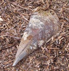
Pinna
sp. Picture taken by Philip Hall
by
After our dive
on the
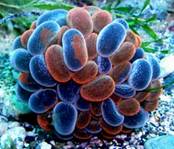
Dennis’s photo of the Swimming
Anemone,
Phlyctenactis tuberculosa
We continued
swimming towards the shore with me leading a little to the left. I stumbled
across a channel of sorts. I hope to think of the word that would describe it
best in a moment. As I approached the channel I could see that it was teeming
with fish of all kinds, like a giant aquarium. I saw a large school of
Long-finned Pike surrounded by lots of Senator Fish, Old Wives, Moonlighters,
Bullseyes, Leatherjackets and Trachinops. It was great just wandering around amongst all
of the fish. Dennis wasn’t satisfied though. He kept busy checking out many of
the holes beneath the algal canopy. He found several Blue Devils there. This was
to be only a short ½ hour dive so we soon had to turn back and retrace our way
back towards the boat. Back at the anchor line Dennis took this photo of myself ascending.
Dennis’s photo of Steve
ascending after the
dive.
It had been a nice
relaxing dive and well worth a second look in the near
future.
Two Riverboats That Sank In SA’s Gulfs
by
According to
“Paddlesteamers and Riverboats of the
The
Avoca was built at Milang in 1877. It was moved
to Port Adelaide in 1891 so that it could be used to tow barges in the
As for the
Ulonga, she sank off
The Ulonga was first built as a paddle steamer for work
on the
She was
sailing up the gulf from
Peter
Christopher’s book “South Australian Shipwrecks – A Data Base 1802-1989” says
that the sinking was reported in the next day’s Advertiser (7/7/76). It also
says that the Ulonga was a 119-ton composite
power schooner with three masts. It gives her cargo as gypsum and possibly one
car.
There were no
casualties as the captain and all of her crew escaped in a raft. They were then
picked up and taken safely to port. Some cattle are said to have drowned
though.
“Ketches of
She had been
built by Permewan, Wright & Co. Ltd at
She was
rebuilt in 1948 as a three-masted schooner with
auxiliary twin screws. That is why she is now known as the AV Ulonga, AV standing for Auxiliary Vessel. Her
new tonnage became 99 net tons and 119 gross tons. At that time she measured
110.7 feet in length, 22 feet in breadth and 6 1/2 feet in depth.
She was then
registered at Port Adelaide in January 1949. Her owners were Ulonga Shipping Ltd and R.Fricker
were the managers of her.
According to
Parsons, when the Ulonga sank she was under
offer to a buyer who intended returning her to the
“Redgum & Paddlewheels – Australia’s inland river trade”
by Peter J Phillips says that in 1976 plans were made to take the Ulonga back into the Murray River and convert her
back to a passenger steamer. The full plans had already been drawn up by a naval
architect when she sank near Normanville.
“Redgum & Paddlewheels” also says that the Ulonga was a sister ship to both the Pevensey and the Wanera. Both of these other ships were owned by the
same company as the Ulonga (Permewan, Wright & Co.). The Pevensey herself was built on the Moama slipway in 1909. She was first a barge called the
Mascot. She was then converted into a paddle steamer and was powered by a
She was very
similar in appearance to the Ulonga and
the Wanera, although she apparently had a bluffer bow.
She also was a similar size to that of the Ulonga. Her length is given as 111 feet and her beam
(breadth) 23 feet. She was 30 feet across the ‘sponsons’ (platforms projecting from the ship’s sides). Her
paddlewheels were 14 feet in diameter and her paddlebox carried the large red circle (spot?) of the Permewan, Wright & Co. with her bluffer bow, the Pevensey was more difficult to control and it was
hard work keeping her on course. A derrick crane was fitted on to her foredeck a
few years after her construction.
“Redgum & Paddlewheels” gives a detailed account of the
history of the Pevensey. It seems that she was
named after a shearing shed. She was able to carry either 120 tons in her holds
or 90 passengers.
Both “Redgum & Paddlewheels” and “Paddlesteamers and Riverboats of the
“Redgum & Paddlewheels” has a picture of the Ulonga on page 75 and the Pevensey on page 76. On page 82 is a picture of the
Ulonga’s barge, the Echuca. Two pictures of the Ulonga (One with the Echuca) are featured on page 84. Another two pictures
of the Ulonga are featured on page 132
(including one of the Moama slipway). There are another two pictures of the Pevensey on page 164.
In 1932 the
Pevensey caught fire and burned near Morgan.
Only the hull, the boiler and engines remained of her. She had to be rebuilt at
the Morgan wharf. The PS Decoy was being dismantled at the time and her
cabins were transferred to the top deck of the Pevensey. According to “Redgum & Paddlewheels”, the words ‘Decoy – Fremantle’
can still be seen on the rear-cabin front wall. This probably means that the
Pevensey (that is now said to be kept at
the Echuca wharf) doesn’t resemble the original PS
Ulonga too closely.
A good history
of the Ulonga is given on pages 132-3.
She is described as one of the finest steamers in the wool trade. At the height
of the trade she could carry (with her barge) 2230 bales of wool. That was 850
bales in the steamer’s holds and 1650 bales on the Echuca (five tiers high).
The Ulonga kept going long after the wool trade passed.
She was then sold in 1948 and steamed towards Port Adelaide. She damaged her bow
in a collision with a larger steel steamer. Her bow was later sheathed in metal.
It was then that she was converted to a twin-screw auxiliary ketch with three
masts. She then traded between the ports of
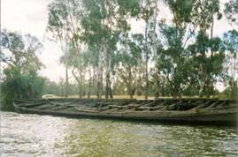
An abandoned riverboat hull on
the banks
of the
taken by Steve & Noeleen Reynolds
“Redgums” says that it is possible that part of her gypsum
cargo may have become moist, expanded and sprung her seams. In the July 2003
issue of Dive Log Australasia, Christopher Deane said in his “South Aussie
Snippets” column that you can still see the plank that sprung loose in her bow,
causing her demise. Chris also gave her location as S 35 25.433, E 138 03.760
(wgs 84 datum).
The Ulonga’s sister ship, the Wanera was apparently at Mildura for many years, taking passengers to Wentworth and
up the
The Moorara was wrecked at
Evan’s
article, titled “Report on the Wreck Moorara”,
said that she was a three-masted ketch and
approximately 30m in length. The book “Wardang Island
Maritime Heritage Trail” published by the State Heritage Branch of the
Department of Environment and Planning, however, says that “The Moorara was originally built in 1909 as a composite
barge at Echuca in
The book goes
on to say that “in 1930 it was altered to a three-masted fore-and-aft rigged schooner with an auxiliary
motor”. Its measurements are given as 33.8m (111 feet) in length, 6.4m (21 feet)
in breadth and 1.6m (5.3 feet) in depth. Her displacement is given as 100 gross
tons.
There is a
picture of the Moorara as a barge on the river
in the book “Redgum & Paddlewheels –
The converted
AV Moorara was used as a local coaster and
as a ‘lighter’ ferrying wheat from Port Victoria jetty
to the larger vessels at the nearby anchorage. She was later used to carry water
and supplies to nearby
I now see that
the MacIntyre is also one of the Wardang wrecks that were previously a river barge built at
Echuca (in 1877). Only the Monarch was built
elsewhere in
“South
Australian Shipwrecks – A Data Base 1802-1989” by Peter Christopher mentions
that the masts from the Dorothy H Sterling were used on the Moorara. The Dorothy H Sterling had been a
large (267 feet) wooden six-masted schooner built in
The Garden
Island Ships’ Graveyard is located on the southern side of
The Dorothy
H Sterling is the first of the two vessels lying east of the main
accumulation of wrecks (towards the Barker Inlet). These two vessels comprise
the Dorothy H Sterling and the
For more
details about ships’ graveyards of SA, including the Garden Island Ships’
Graveyard, check out the website at www.shipsgraveyards.sa.gov.au
. It gives details such as how the PS Jupiter was discarded at
Mutton Cove, adjacent to the submarine base, in the
“South
Australian Shipwrecks” by Christopher says that the tonnage of the Moorara was 98 tons. “Ketches of
She was sold
to Mr G Price, the owner of
This book also
gives the location of the Moorara as being at:
- Latitude: 34° 28.8'S, Longitude: 137° 23.0'E.
Evan John’s
article (Report on the Wreck Moorara) gives the
following bearings (in degrees grid*): - From Bird Point to the wreck 7°,
Lighthouse to the wreck 58.5°, Base of jetty to the wreck
139°.
* The article
actually read “in degrees true” but this was in error.
John says that
the Moorara (in 1979) was located on the side
of the channel which borders the eastern edge of
According to
“Wardang Island Maritime Heritage Trail”, “The remains
of the Moorara consist of the hull still
basically intact and sitting upright, but listing slightly to port. The masts
and rigging have been salvaged. The remains are said to lie in only 4m of water,
with the deck of the bow and stern being only 1-2m
underwater.
John, however,
says that the top deck is (was) laying 2-3m below the surface. He said that the
Moorara had “settled in a groove worn into the
limestone by its keel and, although it lists about 30° to port, it is firmly
held by the groove in the substrate”.
ANY OTHER
CONNECTIONS?
Apart from
being riverboats that left the river to work in SA’s
gulfs, are there any other things connecting the Moorara and the Ulonga? There may well be, although it may only be
through the Ulonga’s sister ship, the Pevensey. The picture of the Moorara as a barge on the river with the PS
Decoy on page 134 of the book “Redgum &
Paddlewheels” is the clue. Unfortunately, I don’t know what the connection is
between the Decoy and the Moorara
but, as mentioned earlier, the Pevensey
caught fire in 1932. She had to be rebuilt and the Decoy’s cabins were
transferred to the top deck of the Pevensey.
REFERENCES:
“South Australian
Shipwrecks – A Data Base 1802-1989” by Peter Christopher. Published by The Society for Underwater Historical Research,
1990.
ISBN 0 9588006 1
8.
“Paddlesteamers and Riverboats of the
“Ketches of
“Redgum & Paddlewheels –
“
“Marine Life
On Wardang Wrecks” by
“Report on the Wreck Moorara” by Evan John, MARIA Journal No.1, October
1979.
“Wardang Island Maritime Heritage Trail” published by the
State Heritage Branch of the Department of Environment and Planning, 1991. ISBN 0 7243 8629
7.
July 2003 issue of
Dive Log Australasia (Christopher Deane’s “South Aussie Snippets”
column).
Ships’
graveyards of SA website at www.shipsgraveyards.sa.gov.au
.
Leafy Seadragon Festival
The inaugural Leafy Seadragon Festival will take place on the Southern Fleurieu Peninsula from 13th to 23rd
April 2005. The Festival will be a celebration of the arts and nature, and will
draw attention to the marine environment and, in particular, the rare and
endangered Leafy Seadragon found in the waters of
There will be a wide
range of activities occurring across the district. The festival will include the following
exhibitions, workshops, readings, music, competitions and demonstrations:
-
An exhibition of
facsimile drawings from the 1802 Baudin voyage entitled “Early
French Voyages to
An exhibition of original
Norman Mitchell cartoon drawings published in the news from 1950s to 1970s.
(Both exhibitions are at the Links Lady Bay Hotel and Golf
Club.)
Landscape as art (to be
photographed from the air) including the creation of giant artwork such as a
Leafy Seadragon made of multi-coloured thongs on the
beach at Carrickalinga, artwork by a local artist and
the students of Rapid Bay Primary School on the hillside at Rapid Bay and
artwork on the hills of Cape Jervis by a professional artist working with the
community.
An exhibition involving 3
dimensional art such as textile art, wood and stone sculpture, jewellery, etc.. (with a People's Choice Award).
A dragon (similar to
those used at Chinese new year) made in the shape of a
Leafy Sea Dragon.
An
environmental and underwater photographic display (supported by MLSSA) at the
Yankalilla Bay Visitor Information
Centre.
Other activities include
skateboarding demonstrations, a skateboard decorating competition, a quilting
exhibition, a national short story competition (with a first prize of $1,000),
kite decorating and flying demonstrations, a photographic exhibition
at Second Valley, an art trail linking all the venues across the district,
story telling, poetry readings and a best-dressed business
competition.
The first three days of
the festival coincide with National Youth Week and the last 3 days of the school
term, enabling schools of the district to incorporate curriculum-based learning
with the Leafy Seadragon Festival. It then continues
through the first week of the school holidays with a number of activities to
encourage participation of young people and families, making this an event for
all ages.
Michelle Hales,
Economic Development/Tourism Officer,
District Council of Yankalilla.
Ph: 8558 2999,
Email: tourism@yankalilla.net.au
.