Marine Life Society of South Australia
Inc.
Newsletter
May 2009
No. 365
Next Meeting
The next Meeting will be the
2009 Annual General Meeting of MLSSA. The meeting will be held Tuesday
the 19th May.
This will be held at the Glenelg Marine
& Scuba upstairs training room (the old Adventure Blue clubrooms)
on the Patawalonga frontage at 8.00pm. Please enter via the stairs at the side
of the building. If you cannot find us on the night then phone me on 0407395566
and I will give you directions.
Our speaker will be Simon Goldsworthy
who will be speaking about seals.
Following the talk we will be holding our AGM.
Committee Nominations
POSITION NAME NOMINATED BY
President Philip
Hall Self
Secretary Neville
Skinner Self
Treasurer Phill
McPeake Self
Committee David
Muirhead Self
Committee Chris
Hall Self
Non Executive positions will be filled by
volunteers expressing interest at the AGM.
CONTENTS
Committee Reports
Sand Damage to O’Sullivan
Reef in early 2009 (Helen Crawford)
Please Note - Memberships are now due!
President’s Report
2008/9– Philip Hall
I have said in other
years that my report would be very similar to that given for the previous year
or two and this applies yet again.
2008/9 has been another
good year for MLSSA. I have been able to give several talks to Service and
other community groups mainly during 2008, none so far this year. They have
been individualized for each talk by judicious use of the Photo Index and
calendar pictures. The Digital Projector and laptop have performed well and has
been invaluable for use by speakers at our own meetings.
A while ago we became the
lead group in an attempt to get full protection for the Western Blue Groper and
the Harlequin Fish. We continue to wait for a decision. Apparently several
Government Agencies have to release their reports before a final decision can
be made.
Attendance at our own
meetings has again been the only downside to the year. Generally only a regular
few turn up in spite of having excellent speakers on a variety of interesting
topics. Since changing the day of our meetings to the third Tuesday in the
month we have met at the Adventure Blue Clubrooms at Glenelg. Recently they
closed their operations at Glenelg. Fortunately the new proprietors, Glenelg Marine
and Scuba, have allowed us to continue meeting at the upstairs training room.
The 2009 calendar has
been a great success with us selling almost all 1200 copies. We have made a
small profit to be added to that of previous years. These funds are intended
for the production of the Beachwash Guide. The 2010 calendar is ready for the
printer due mainly to the effort put in by Phill McPeake in recreating it from
scratch in a new programme now used by the printers.
We continue to get
requests for help from the public mainly by email and these have either been
answered directly or they have been referred to the appropriate organisation.
Email traffic is monitored by me and averages 10/15 items a day that need
either acknowledging, replying to or forwarding to various groups within MLSSA.
The website continues to
operate under the care of Ralph and apart from the odd downtime due to
powerouts has been very stable. Danny has made a final upload to the Photo
Index and now Ralph will completely redesign the site so I will be able to make
the uploads more promptly in future.
A big thank you must go
to the CCSA staff for allowing us to use their premises as a post box.
I would like to thank the
Committee for their assistance and enthusiasm. A special thank you to my wife
Margaret for attending all meetings when she has no real need to do so - apart
from keeping me in order and producing many “left of field” solutions.
Treasurer’s Report 2008/9
- Phill McPeake
This will be presented at the AGM.
Secretary’s Report 2008/9 – Neville Skinner
Another busy year has
passed that has seen me join one more committee - the Joint Steering Committee
for the West Coast & St Vincent Gulf Prawn Fisheries Association
co-management project. This committee comprises three groups - the Prawn
Fisheries Association, Government (incl PIRSA, SARDI) and Conservation (CCSA),
and is funded by the Fisheries Research & Development
Council. Fisheries co-management is defined as an arrangement in which
responsibilities and obligations for sustainable fisheries management are
negotiated, shared and delegated between government, fishers, and other
interest groups and stakeholders. The purpose of the joint steering
committee is look at several management models to find one that allows the Prawn
Fishers to do take on more responsibility in the running of a sustainable
fishery that has lower Government costs associated with it. From talks
held to date with the Prawn Fishers, it is evident they are sincere in their
desire to set a new standard in sustainable and environment-friendly management
of their fishery that includes input from the conservation sector. This is an
ongoing process that may well take another 2 years, however progress has been
very constructive and all parties are optimistic of a positive outcome that
will not only set a standard for all fisheries Australia-wide, but world wide,
as this will be the first time this has ever happened.
(Further info may be
obtained from
http://www.frdc.com.au/commercial/comanagement/index.php
and
http://www.frdc.com.au/commercial/comanagement/Co-management_report.PDF)
Late last year DEH
proposed a new management plan for Ewens Ponds that would see the banning of
all SCUBA diving activity in the Ponds. This has caused a strong response
from divers, as well as many non-divers. DEH suggested in their proposed
Management Plan for the Ponds that divers were contributing to the serious
algal bloom problems in Ewens (reported by myself on several occasions in the
past).
On behalf of MLSSA I
wrote a response to the DEH Ewens Ponds Management Plan proposal, which was
submitted just before Christmas (literally). (Details of this response may
be found in your February newsletter.)
The SDF also put in a
detailed response to DEH, but followed theirs up with a recent Press release
that included the Mt Gambier newspaper ‘The Border Watch’ (TBW). TBW
responded to the SDF asking for more information that resulted in the SDF
directing TBW to myself. I have since been in communication with TBW and
have undertaken to meeting with the TBW reporter on-site at Ewens Ponds, where
I can walk through the system and explain the issues. I am hopeful this
will also include one of the Mt Gambier Councillors, who has also shown an
interest in the dredging activities that take place in Eight Mile Creek, as a
result of reading a copy of my 2004 article on the “Dredging of Eight Mile
Creek”.
This is likely to happen
in the next 3-4 weeks, if not before.
In closing, I would like
to thank my fellow Committee members for their ongoing support and their
commitment to MLSSA.
Committee
Members Report 2008/9 - Chris Hall
2008/2009 has seen MLSSA
produce & sell another outstanding calendar. Thanks to all those involved
in the publication & selling of the 2009 calendar. 2010 calendar is
underway & as usual there will a number of great photographs, so many
thanks to the photographers for their time & considerable effort not to
mention the personal cost to them.
We have had some brilliant
guest speakers this year but what a pity that only a few members have attended
our meetings especially as the topics cover such a variety of subjects.
Unfortunately I haven’t
done as much diving as I would have liked but was involved with Janine Baker in
her rare fish surveys. The most enjoyable was diving previously undived sites
for me on Kangaroo Island. I would urge anybody that has an interest in these
surveys to contact Janine as it is all voluntary & she needs all the help
she can get.
Due to ill health & a
need to do a dive medical I haven’t been in the water at all this year but I am
hoping that will change shortly & I can continue to support MLSSA with more
photos & info I gather from each dive. As a result of this I haven’t been
able to monitor Hallet Cove reef for Reef Life Survey with Steve Reynolds but
I’m hoping we can start in the spring.
It was good to see a
number of MLSSA members at the Fish Forums run by CCSA, I recommend them to all
as they are of interesting topics & great information.
I would like to thank the
committee for all their support & tireless efforts to keep MLSSA going
especially Philip & Margaret who are great ambassadors for the
organization.
I hope 2009/2010 is as good as previous years
& I urge all members to attend all our meetings so that our patronage to
MLSSA meetings increases.
Committee Members Report
2008/9 - David Muirhead
When you’re running late
for a dive which I often am, and one is thus in a rush getting one’s gear
ready, it doesn’t necessarily translate into a crummy dive: however when you’re
running very late to do your committee report it generally does translate into a
crummy report!
However for all the ups
and downs of a very erratic year for me and I think for MLSSA , I have still
managed to squeeze in some excellent diving, mainly local stuff down near the
shack but with the notable exception of a
trip to the Chain Of Bays area on the West Coast about two months ago.
I couldn’t resist filling
in at short notice along with fellow MLSSA member Helen Crawford, as the only
two members of the South Australian diving contingent who had been listed for
this volunteer marine life reef survey organised by the Friends of Sceale Bay
ie Scoresby Shepherd and Janine Baker were unfortunately both unable to go at
short notice due to illness and other commitments respectively.
Although we did have a
good time and took some nice photographs unfortunately we had a job to find
anything rare or uncommon which was our agenda, as the agenda of the interstate
divers was essentially confined to doing standard line transect reef surveys,
and for a number of reasons they got priority in their wishes.
Still, other than
realising that its generally best to just have the one agenda when there is a group
of divers on expedition, I’m not complaining because after all we still had
some good diving and I was able to play around with my new digital camera set
up-yes folks I finally did bite the bullet!
Please refer to the first
sentence for what is in effect a less than humble apology by one of MLSSA’s
more eccentric committee members.
I’m now frantically
ramping up for another expedition this time to the Sir Joseph Banks island
group in May with Departments of Environment and Heritage and Fisheries.
As they say: ‘One’s
working life’s a bitch... and then you dive’'.
SDF Officer’s Report
2008/9 -
Neville Skinner
This year I have
managed to get to most of the SDF meetings, but find it is a struggle to get
there (Marsden) in time for the committee meetings at 7pm.
Some of the key
issues covered by SDF this 12 months have been management of the ex-HMAS
Hobart, insurance for divers (keeps popping up), Rapid Bay Jetty and Ewens
Ponds, as well as issues from SARFAC (recreational fishing association) and
other groups.
Recently the SDF
has been very successful in seeking the right to manage diving on the Hobart,
with DEH & others clearing the way for this to happen. At this stage it looks like the SDF will be
looking after Public Liability insurance, bookings and receiving fees for all
divers wishing to dive on the Hobart in the very near future.
The SDF was
instrumental in getting the new Rapid Bay Jetty built, and was on the design
committee for the new Jetty.
They have also been
on the Underwater Trails committee with DEH and have been able to voice their
input into decisions involving same.
The SDF has been a
very active in the debate surrounding the newly proposed Management Plan for
Ewens Ponds that in my opinion should never have seen light of day in it's
current ill-considered form. The SDF
also sent out press releases on this subject that has encouraged requests for
more information from Mt Gambier's ‘The Border Watch’. I am hoping to report back on this in the near
future.
There have also
been many other smaller issues that SDF gets involved with during the year (I
cannot remember them all) that makes them a very active group that I think
represent good value for MLSSA to be part of.
And I'm sure Steve
will remind me later of all the other important issues I should have mentioned
in this report...
Editor’s Report 2008/9 –
Philip Hall
The Newsletters and 2008
Journal have continued to be produced at a high standard and since August 2008
most editions have had full colour pictures in the hard copies. This is thanks
to Phill McPeake and his colour Laser Printer.
I have found great
difficulty with motivating a variety of contributors for the Newsletters. We do
need members to send in articles on a regular basis to give a variety of views
and opinions.
Newsletters have continued to be sent to members
requesting it as a PDF file. This enables full colour pictures to be received
and avoids the need to download from the website. I try my best to ensure that
the file sizes are kept to the minimum to ensure that dial up service time for
download are reasonably short.
Library Officer 2008/9 – Steve Reynolds
The situation regarding
our library has not changed since last year at all. 1 or 2 members sometimes
read new items before being stored away for eternity. We sometimes receive an
outside enquiry regarding library items. We rarely, though, receive internal
enquiries. I, myself, find the library very helpful in my various roles:
article writer, Photo Index Officer, SDF Secretary, etc.. The Society has now
agreed to assist me with my printing costs, allowing me to print out hard
copies of relevant papers for inclusion in our library. Once again, if I am
re-appointed to the position of Library Officer, please let me know if you wish
to borrow any items from the library.
Photo Index Officer
2008/9 –
Steve Reynolds
The Index is trying to
keep up with modern technology. All new entries will be digital images from now
on. All images will be stored on high capacity disk drives. The Society is
providing me with a 1TB hard drive to facilitate this storage of images. There
appears to be no shortage of images suitable for the Index, but the provision
of all of the relevant information regarding the images has been holding back
any progress for the past two years. It is important that as much information
as possible regarding Index images should be provided at the time of processing
so that the process can be completed promptly. This means information such as
ID of the subject (scientific name if possible), date, location, depth, etc.. I
dare say that if this information had been forthcoming in the past two years,
the Index would be much larger than it currently is.
Reef Watch Officer 2008/9 – Steve Reynolds
I personally haven’t been
active in Reef Watch matters in recent months (years?) but I do try to keep up
with what’s happening within Reef Watch and then pass that information on to
our members through our monthly meetings. We haven’t participated in any recent
Reef Watch events or monitoring dives at all. Let us know if you would like to
become more involved in Reef Watch matters.
Assistant SDF Officer
2008/9 -
Steve Reynolds
Neville Skinner and I are both members of the SDF
Executive Committee (until the July AGM). As SDF Secretary, I attended all but
one of the SDF meetings in the past year. This considerably allows me to
represent MLSSA much of the time. Neville can’t always attend the SDF meetings,
but we will generally have a representative at them. It was just unfortunate
that there wasn’t a MLSSA rep at the one meeting that I happened to miss due to
being away on holidays at the time. Our Society has agreed to pay a levy in
participation of the SDF’s Hobart Mooring Buoy Program. The SDF is a good
platform to discuss issues of concern to divers in general. Again, please let
Neville or myself know of any issues that the SDF could or should become
involved in.
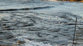
Sand Damage to O’Sullivan Reef in early 2009
by Helen Crawford melon@internode.on.net
The
dredging of the O’Sullivan Beach Boat Launching facility has resulted in a
large amount of sand being dumped directly on top of reef at O’Sullivan Beach
between the ramp and Pt Stanvac. I recently discovered the state of the coast
and reef when my partner went for a regular snorkel there. What was a permanent
rock pool has been completely filled with a huge amount of sand. The inner
channels of the coastal reef have been filled to a depth of metres, in some
places, all the way up to Port Stanvac. This sand that has filled the
intertidal zone and completely filled the previous (semi?) permanent rock pool,
and is now continuing its march over the reef as tidal and wave action carries
it out further each day.
Unfortunately we discovered
the dredging after it had happened. I have however included some pictures taken
by another resident below (with her permission). Another local who saw the
dredging thought that “it looked very concerning”, “it looked toxic… warned
kids to get away from playing near the outfall” and she trusted that “it must
be OK because authorities would surely do the right thing”.
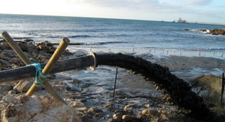
The dredging in process – It was observed that Rubbish
was piped with the sand and silt directly from the marina. The effect of sedimentation
on the local reef is devastating beyond the obvious smothering to death of much
of the sea life by the sand.
I have been regularly snorkelling in the area
over the past year and have enjoyed the biodiversity of this small but rich
reef. Much of this has now been buried alive. See below before and after pics.
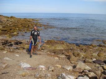
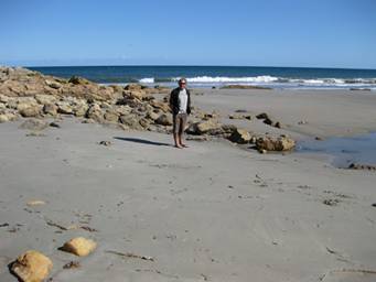
Left picture - Lawrence at the rock pool edge after a
snorkel a month ago.
Right Picture - Standing left of but near the same
site now - on what was the rock pool and is now an extensive sand filled area.
At the reef we
observed and sometimes photographed a range of sea life. I saw a long snouted
boar fish over the last year and have been told that sighting this fish is an
indicator that the reef’s health was reasonably good. I recently saw a number
of cuttlefish that had been using the site for spawning. The eggs will now be
buried along with all the algae and rocks they used to hide under. Also buried
will be numerous sea stars, nudibranchs, anemones, abalone etc. It is very depressing
to witness this destruction of so much nearshore marine life, which is supposed
to be protected under Adelaide’s Living Coast Strategy.
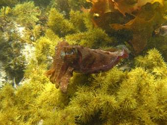
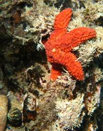
Cuttlefish at O’Sullivan Reef. Feb
2009 Sea Star at O’Sullivans
Reef 2008
The sand
damage fills out across what was one of few inner protected coastal reef areas,
in the metropolitan area, that is accessible from land. I regularly observed
recreational use by other snorkellers. The area has been an attractive nursery
area for many fish, and has been protected from both land and sea fishing to a
degree because of the nature of the topography (channels parallel to the shore
line). The damage visibly extends all the way into the Restricted Port Stanvac
reef – known for it’s coastal value. Due to restricted access, Port Stanvac’s
reef is by default a very rare “no take” coastal Marine Park, and of importance
to our urban marine environment.
The impacts of the dredging on this coastal reef in brief:
1.
Reef life smothered to death under up to 2 metres of sand.
2.
What’s left can’t get enough light because of the turbidity. (murky
water which means the algae can’t photosynthesize).
3.
Both the fish and algae spawn (propagules) can’t get a hold to
germinate/grow because all the sand and silt stops adhesion to the rocks.
4.
Groups of Giant Cuttlefish eggs are killed by smothering, which will affect
the next generation of this species in the area.
5.
Filter feeders (bivalves, sponges, ascidians, colonial ascidians and
corals etc – which include the potentially threatened Plesiastrea versipora) are suffocated or starved by
sand/fine silt turbidity, as are other sessile invertebrates in the area, such
as anemones.
6. The habitat and food supply of
small, rock-hopping fishes (such as blennies) is degraded. Habitat for
mobile fishes is also degraded. We note the presence of a mouth-brooding,
crevice-dwelling cardinal fish species in this coastal reef.
7.
Silt from a marina is usually toxic (from toxins such as hydrocarbons, metals
and antifouling chemicals settling into the sediment and building up in
concentration) and the dredging process releases these toxins and
nutrients into the water.
8.
Any life remaining will now be stressed and open to invasion from
other organisms. (coverage of the reef by
opportunistic species such as mussels, or invasion by exotic species such as
the European fan worm.) or algal bloom (overgrowth by nuisance macroalgae (brown
filamentous); microalgal bloom if the dislodged and smothering sediment
contains excessive nutrients.
To date
the following summarises what I know about the dredging:
1. The dredging contractors Maritime Constructions employed by
(Department of Transport, Energy and Infrastructure) DTEI who were OK’d
by the Environmental Protection Authority (EPA) to dump the dredge materials in
the “tidal zone” as part of general maintenance of the marina. Dredging
guidelines are available at http://www.epa.sa.gov.au/pdfs/guide_dredging.pdf
2. An independent person with appropriate
qualifications and experience is required to verify that the operator has
complied with all these guidelines. That person should stop operations if water
quality criteria are being exceeded.
3. The sand that has been dumped included amounts
of rubbish some of which is imbedded in the new underwater sand and sandy
“beach” area. Lawrence (my partner) observed a large amount of floating rubbish
– mostly plastic, and this was seen floating throughout the waters after
dredging. This appears to have been dispersed now by the waters and currents.
4. Sam Gaylard
from the EPA is looking into some funding to do some follow up monitoring. I
fully support and applaud this. However the issue that this has happened at all
still need to be addressed. Kirsten Benkendorff a marine expert at the
university has some baseline data of the intertidal reefs that should allow
recognition of any significant changes to the intertidal communities relative to
control sites. SA Water has also been doing monitoring around the area in
preparation for the Desalination plant hence there is "before data"
and a Victorian based consultant a few years back when the refinery shut down.
5. Sand moves
naturally northwards along the coast, in this case the spoil from the dredging
will be carried further into the Pt Stanvac reef area. This is already evident
from standing on top of the cliff. However the damage is not restricted to this
path as was seen when in 1997 at Pt Stanvac when dredging for sand hit an old
fine sand dune and the turbid plume smothered the Port Noarlunga Reef. See here
for interesting reading re the impact http://www.reefwatch.asn.au/archive4.html
6. Sand, silt, rubbish and fines all have different
impacts on reef systems and the dredging impact can be better understood if you
take a look at this thesis:
http://digital.library.adelaide.edu.au/dspace/handle/2440/37702.
The
following statement comes directly from the afore mentioned EPA dredging
guideline document:
Dredging can disturb aquatic habitats, spread exotic algae and
invertebrates, re-suspend bottom sediments causing increased turbidity, and
recirculate toxic metals, hydrocarbons, pathogens and nutrients that are found
in sediments in the water column. Turbidity reduces sunlight available to
aquatic vegetation, is known to contribute to seagrass loss and affects the
safety of bathing waters. Physical disturbance and removal of dredged material
in both inland and marine waters can have a substantial immediate and long-term
impact on water quality.
“Code of Practice for vessel and facility
management (marine and inland waters)” – Guidelines
7. The SA Governments directive to protect SA Biodiversity
is clear through the development of the Adelaide Coastal Waters Report. I note
that turbidity is one of the core issues covered in the Adelaide Coastal Waters
Report. http://www.epa.sa.gov.au/acws_news.html
8. The government documents mentioned above were
developed in accordance with International 1996 Protocol: 1972 and 1996
Protocol – please see http://www.imo.org/home.asp?topic_id=1488
and http://www.austlii.edu.au/au/other/dfat/treaties/2006/11.html
9. Dredging of the marina has happened before here and
it will happen again. (The questions is now, where should the spoil go?) Locals
believe it has happened every 3 to 5 years and that it has never been quite as
extensive as this before.
10. The Marina was built in1983. The offshore reef was
blown up in October 1982 prior to the building of the breakwaters. Steve
Reynolds used to snorkel there. The February 1983 MLSSA newsletter
reported how the main (southern) breakwater had reached one of the offshore
rocky reefs. In 1982 he did a scuba dive prior to the completion of the boat
ramp. Steve writes “Unfortunately, I never managed to return there again. My
logbook merely records the fact that I dived there in November 1982 with 4
friends. “But, as luck would have it, I wrote a brief report for the (newly
named) Marine Life Society's newsletter (No 67, December 1982). My report
described how the 5 of us dived in the area just north of the (northern)
breakwater.
The
area was very rocky and there wasn't much greenery (algae) around. The area
looked very grey and desolate at first, but down on the bottom, about 15feet
(4-5m?), there were lots of little gobies and blennies 'hopping' around. There
were rocky reefs running parallel to the shore. At the bottom of these reefs,
on the shore side, were ledges covered with sponges, bryozoans and invertebrate
communities. Larger fish were seen around the area, but there was also a lot of
young life and schools of small fry 'buzzing' around. It turned out to be a
beautiful and interesting dive. Fish sightings that I recorded were: - shark
(juvenile), stingray, moonlighter, talma, zebra fish, dusky morwong, magpie
perch, banded sweep, scaly fin, banded toadfish, globe fish, (red?) gurnard,
various blennies and gobies.”
“Other
issues of our newsletter recorded the progress with the construction of the boat
ramp and breakwaters, etc.. Our February 1983 newsletter, for example,
reported how the main (southern) breakwater had reached one of the offshore
rocky reefs. This meant that rocks were now going to be placed over the top of
the reef to form the continuation of the breakwater. Other reefs in the area
were going to be blown up so that there was no danger to boats. I suggested
that this would mean the end of some of the communities living under ledges on
the reef. Large fish were said to be moving in to the breakwater area. Schools
of trevally, zebra fish and a large bronze whaler shark had been seen. Sand was
going to be laid over rock pools on the beach, covering molluscs, crustaceans
and tiny fish.”
My snorkelling
(and one brief dive further out) revealed similar reef to that described above
and closer to shore a number of beds of thick algae in “groves” between the
reef ridges.
11. Construction of the
Marina appears to have changed the natural flow of sedimentation along the
coast and protected the reef area more allowing a pocket of greater diversity
and rich reef ecology to develop. By the by, according to locals, the sand on
the O’Sullivan beach south from the Marina has never been better. Neither is
the sand from dredging like the “natural” sand that was seen before the
marina’s construction. The dredged sand “looks really dirty straight away from
the top of the cliff” to one man who used to snorkel this site in 1981-82.

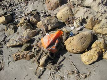
Left: Sedimentation
(everything looks “iced”) and turbidity (low visibility) note red sponge.
Right: Rubbish
imbedded in sand where outfall pipe was.
Photos 7th April 2009
Upon
making some initial enquiries about whether any monitoring took place in
relation to the recent dredging, and how, I received the following response:
“The monitoring you refer to is the 'independent verification' mentioned
in the guidelines. This was supposed to work like an audit - someone
independent of the operator would monitor during the works, and either report
if quality criteria were exceeded, or sign off that it was all done consistent
with quality criteria. These people are paid, but
independent. And their reports are supposed to be on the public record.
The bad precedent came with the dredging for the shipping channel to Outer
Harbour. We are still waiting to find out IF there was 'independent
verification' for that one.
Incidentally, the guidelines on the website (complete
with incorrect e-mail address) were drawn up to provide quick approval of
dredging, PROVIDED that they followed the criteria, which, in turn, reflect the
international Protocol 1996. That is, the material be brought ashore,
held behind bunds while the water cleared to a specified quality profile, then
be returned to the sea. It was all part of the one deal. What has
happened is that Government still gives the quick approval, but waives the
other requirements.
In
your example, that water should be running to a bunded area ashore, held (it
usually only took a few days) and released when OKd by the independent
verifier.”
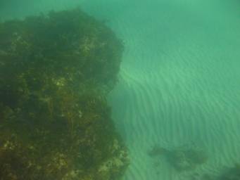
Left – 10.4.09
typical view of sand smothering damage: outcrop beside buried reef/channel.
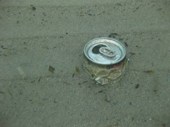
Right – 13.4.09 I counted five drink can ends on a
quick snorkel - some of the newly emerging rubbish.
DTEI have recently emailed a response to enquiries I made. I have been
informed that the Dredging works commenced on Friday 20 February 2009
(just as the cuttlefish were spawning) and were completed on Wednesday 1 April
2009. Here’s the outline of the monitoring process as provided to me by the
DTEI:
“The department has been liaising with the EPA regarding the dredging
and the department has obtained a dredging licence from the EPA to undertake
the dredging works at O'Sullivan Beach. A condition of the licence is
that independent water monitoring be undertaken in the vicinity of the works to
ensure that the water quality is maintained. This water quality
monitoring plan has been endorsed by the EPA. As part of the water
quality monitoring program, the dredging contractor takes samples twice daily
at specified locations and the water sample is tested for various
parametres. The results are monitored and reviewed by an independent
auditor. The EPA also inspected the works site on 27 February 2009 and
they subsequently advised DTEI that they had no issues with the dredging
operations.”
This recent addition to my knowledge of the matter raises
more questions and does nothing to allay concerns described above.
This has truly shaken any confidence I had that the EPA can adequately monitor the impact of a major development like the desalination plant when they approve the dumping of sand on reef areas such as this, with ineffective monitoring, and what appears to be inaction in response to public concern? What dismays and truly surprises us is that this doesn't look to be a mistake - but standard practice.
Helen Crawford
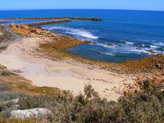
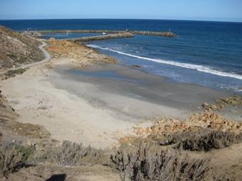
O’Sullivan reef before note rocky
coast line and rock pool (left) – after dredging was completed (right)